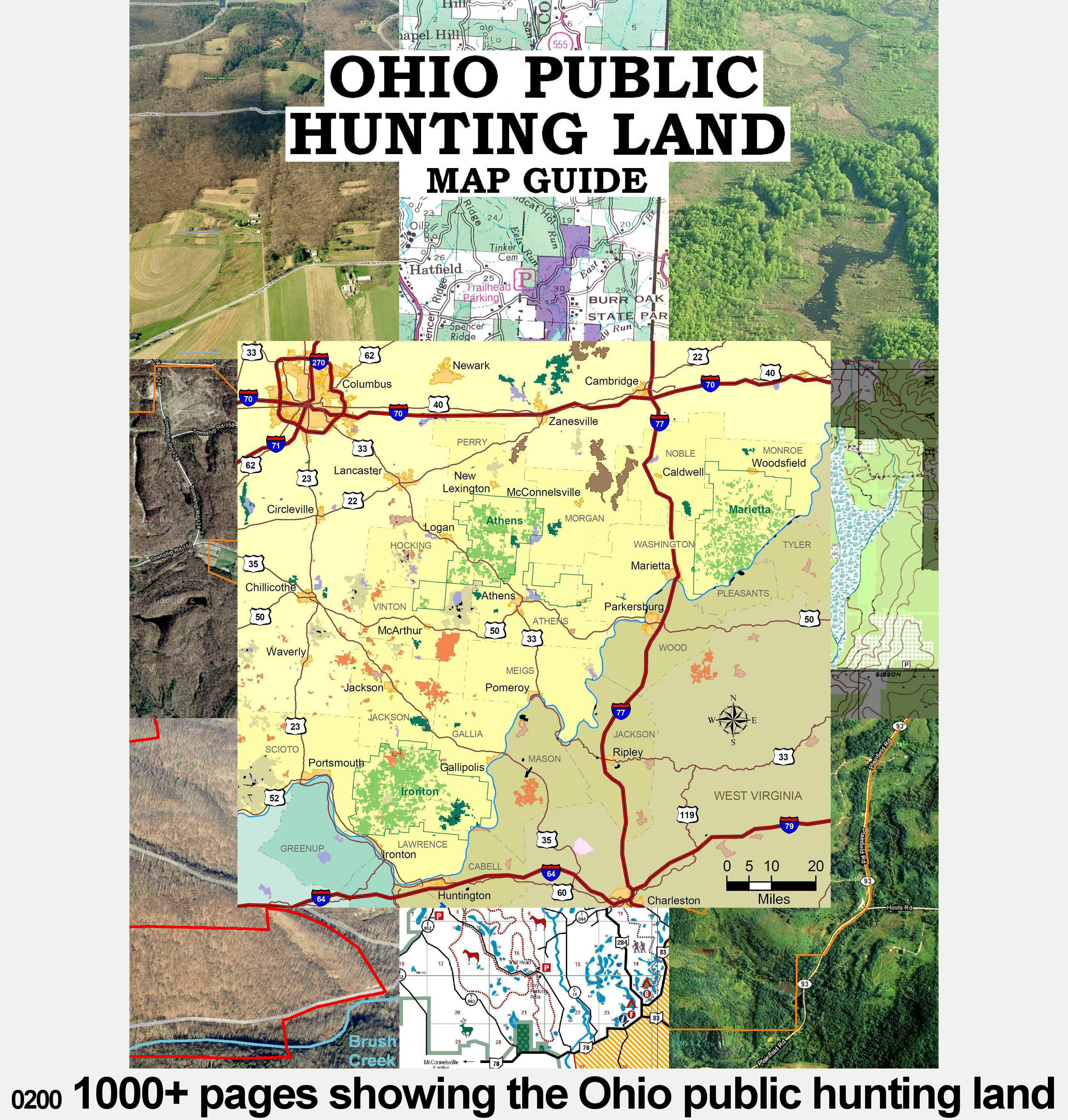
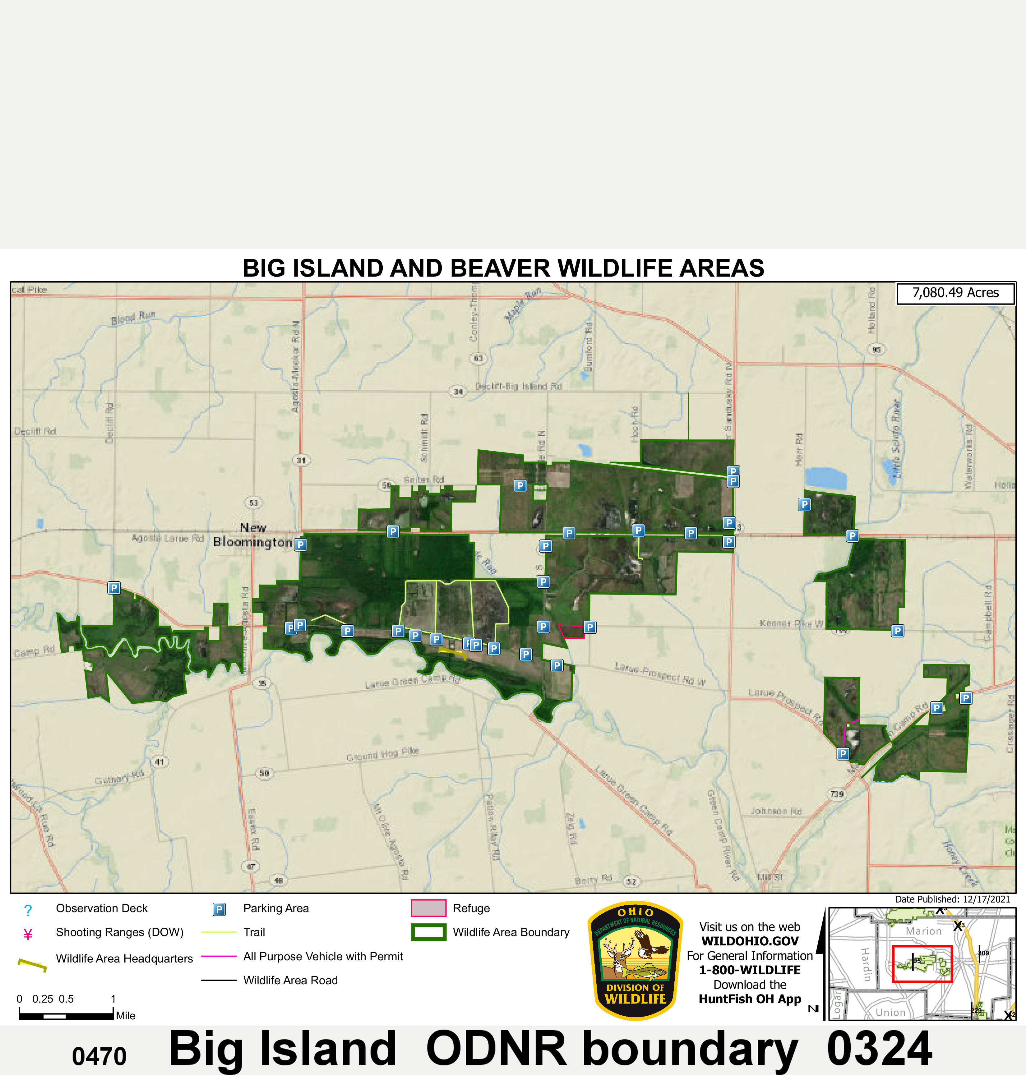
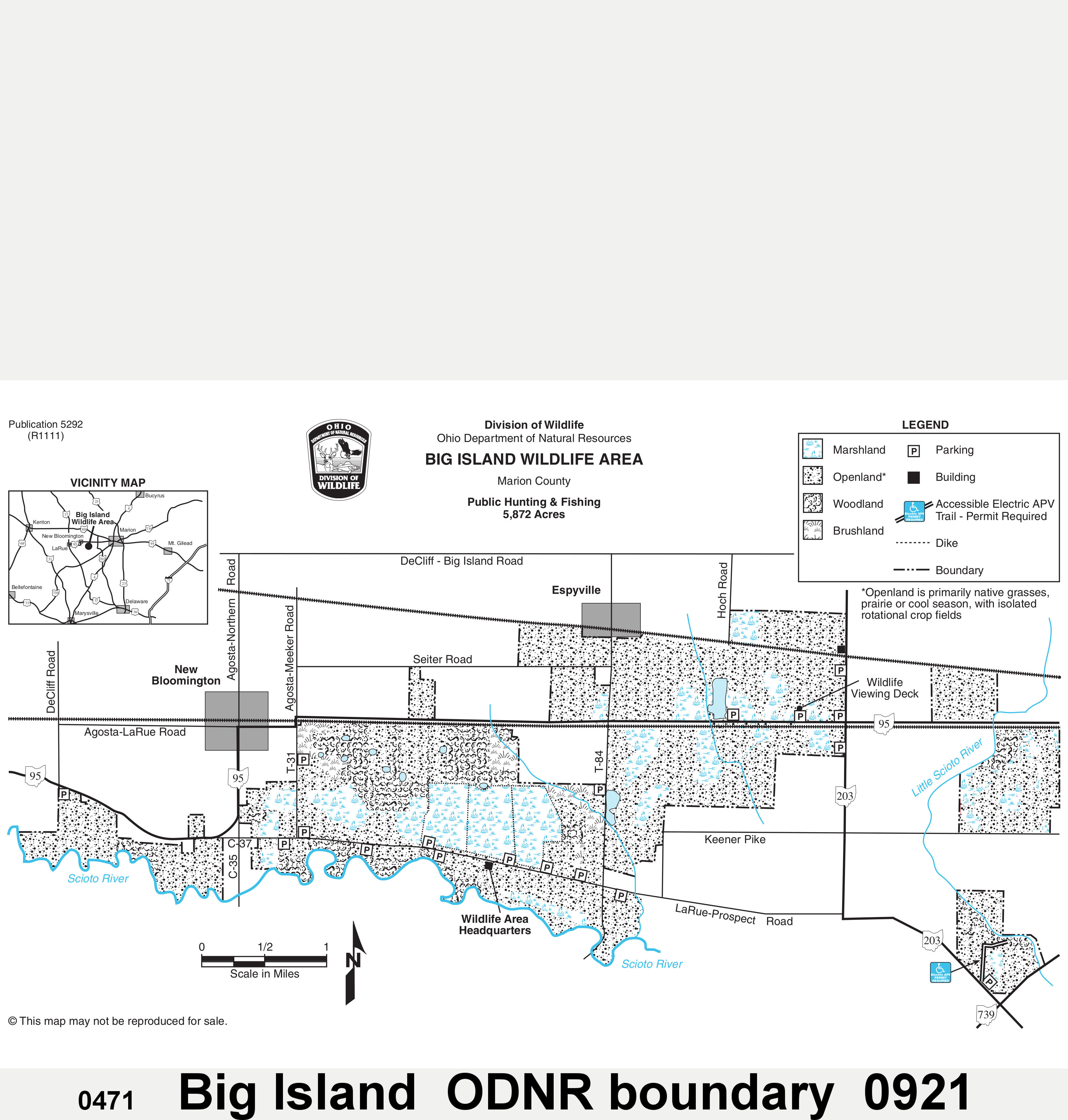
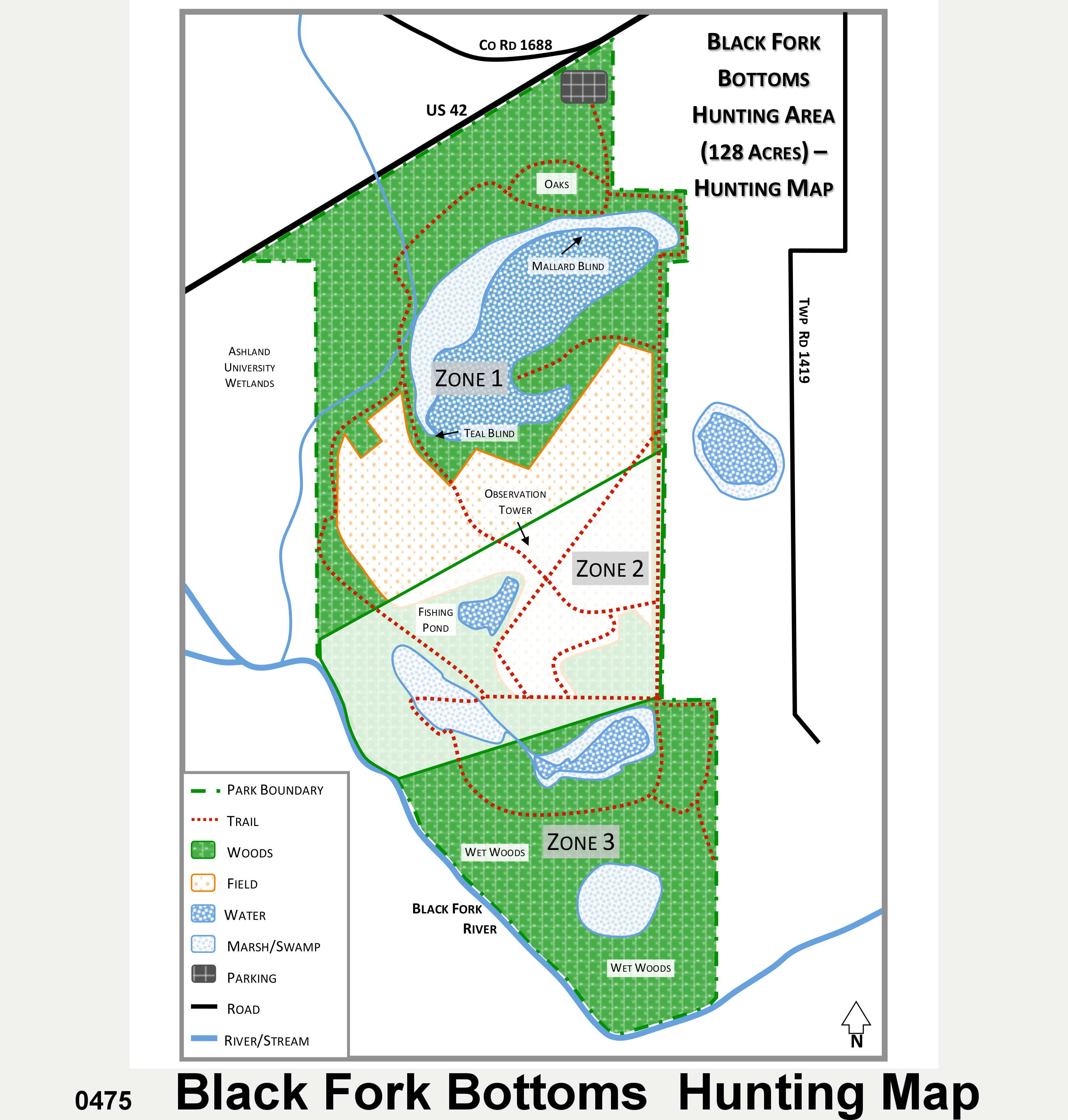
1400+ pages Public Hunting Land Maps, Photos, Topos, ODNR lands, MWCD, AEP, Wayne N.F., State Forests + Parks, USGS, Complete Area List, Birdseyes, Guide.
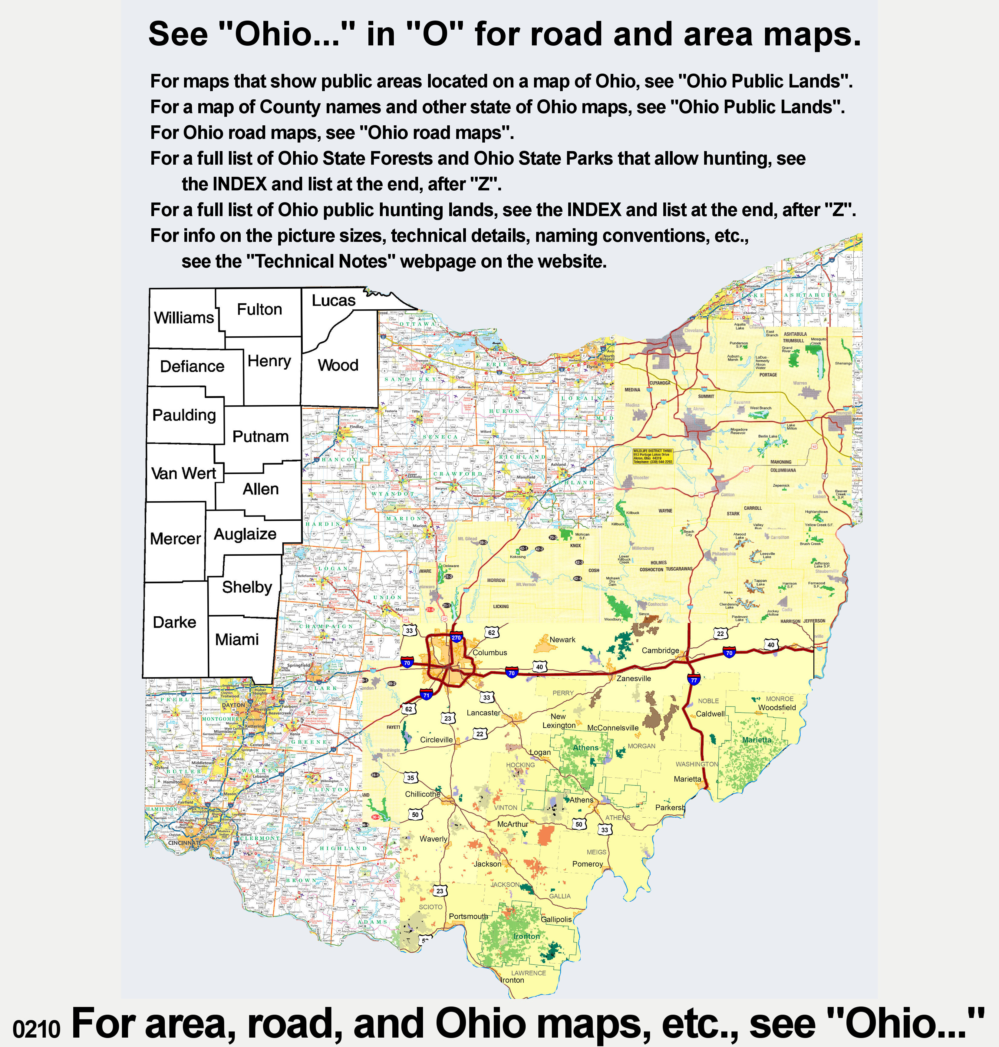
Click the 3 links above for the other Main Gallery pages. All areas are alphabetical over 4 webpages. Page 1 below shows areas A – B. Click on a picture below to enlarge it. Click again to enlarge it more.
Click the 3 links above for the other Main Gallery pages. All areas are alphabetical over 4 webpages. Page 1 above shows areas A – B.
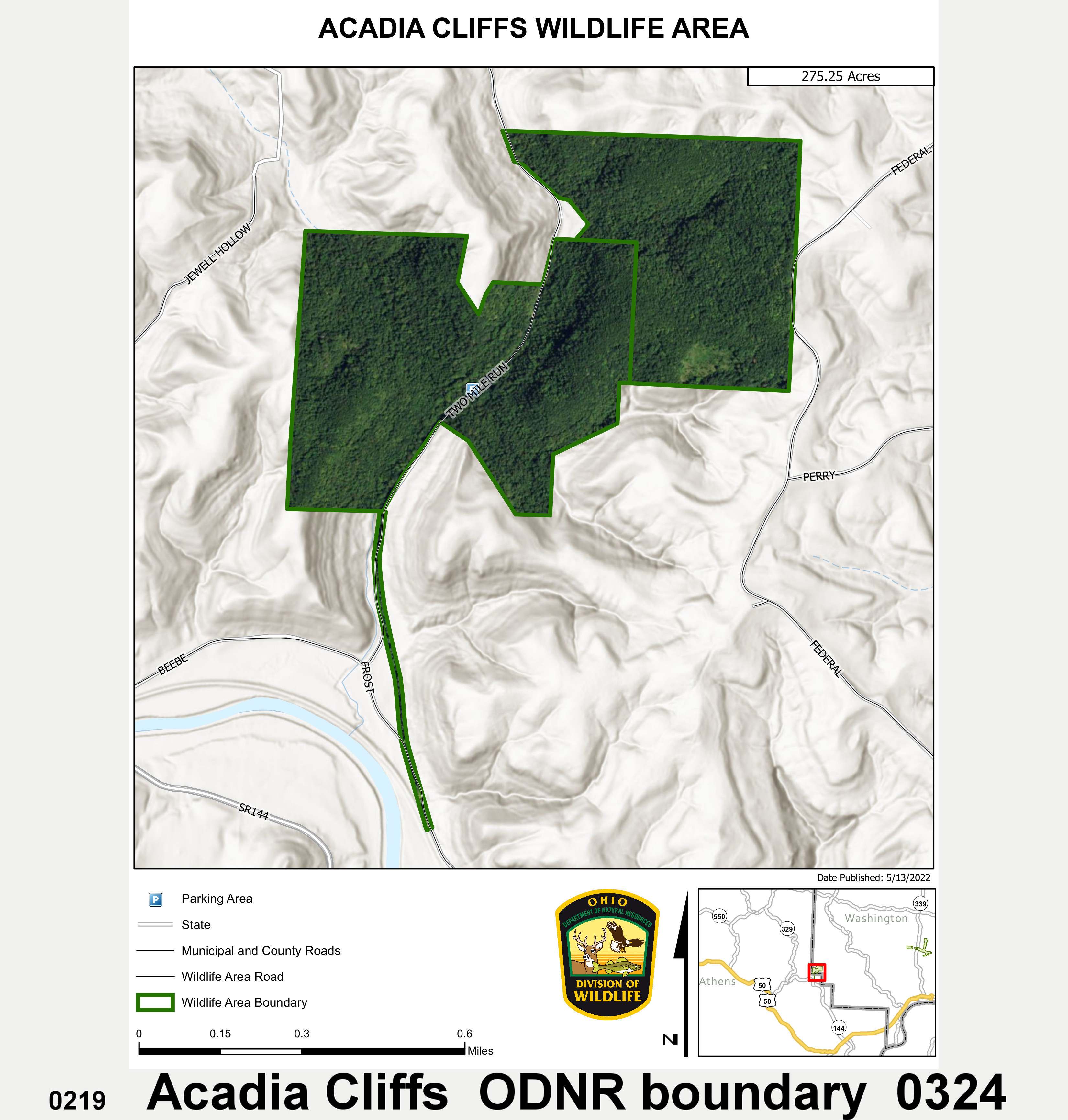
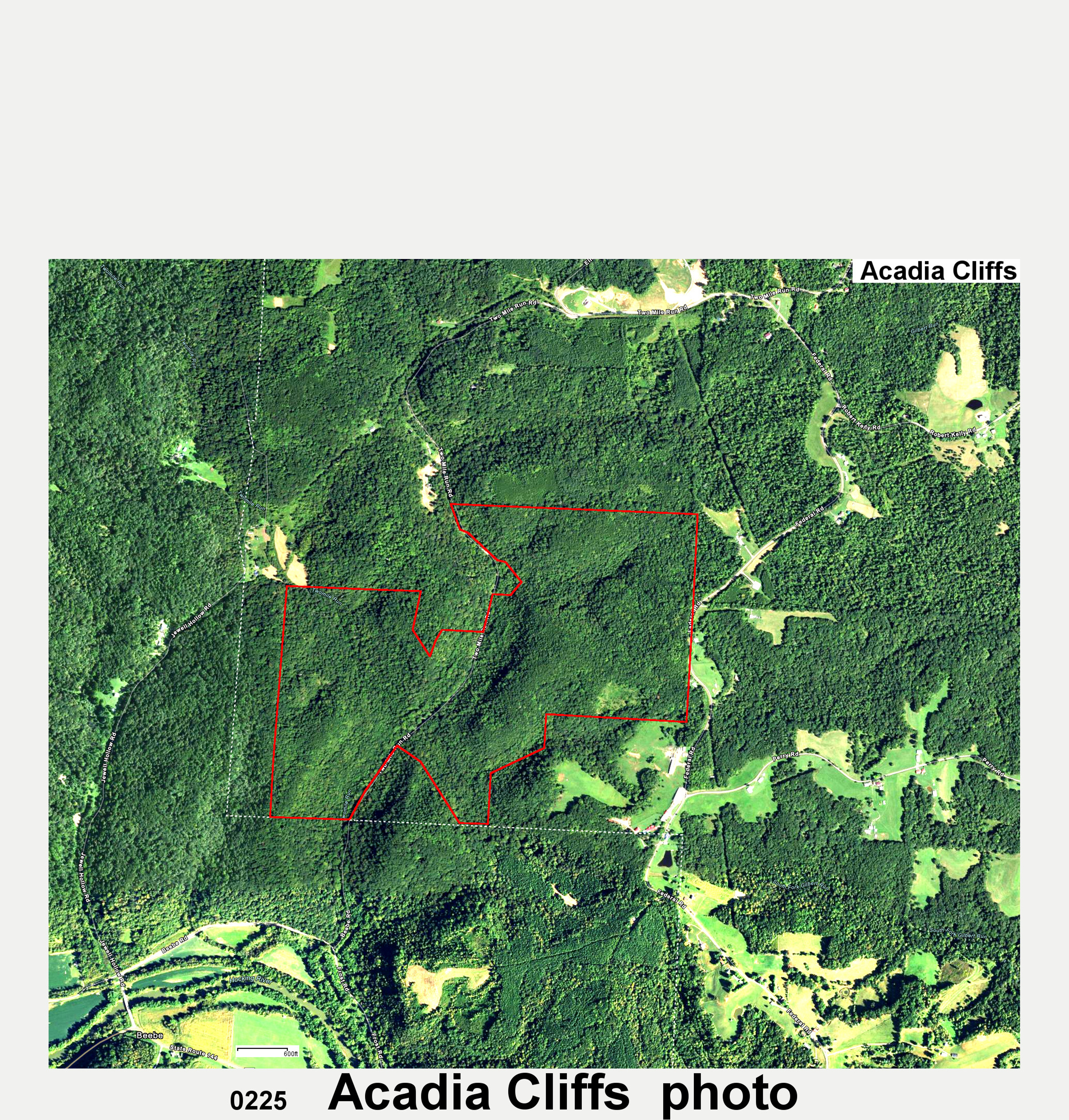
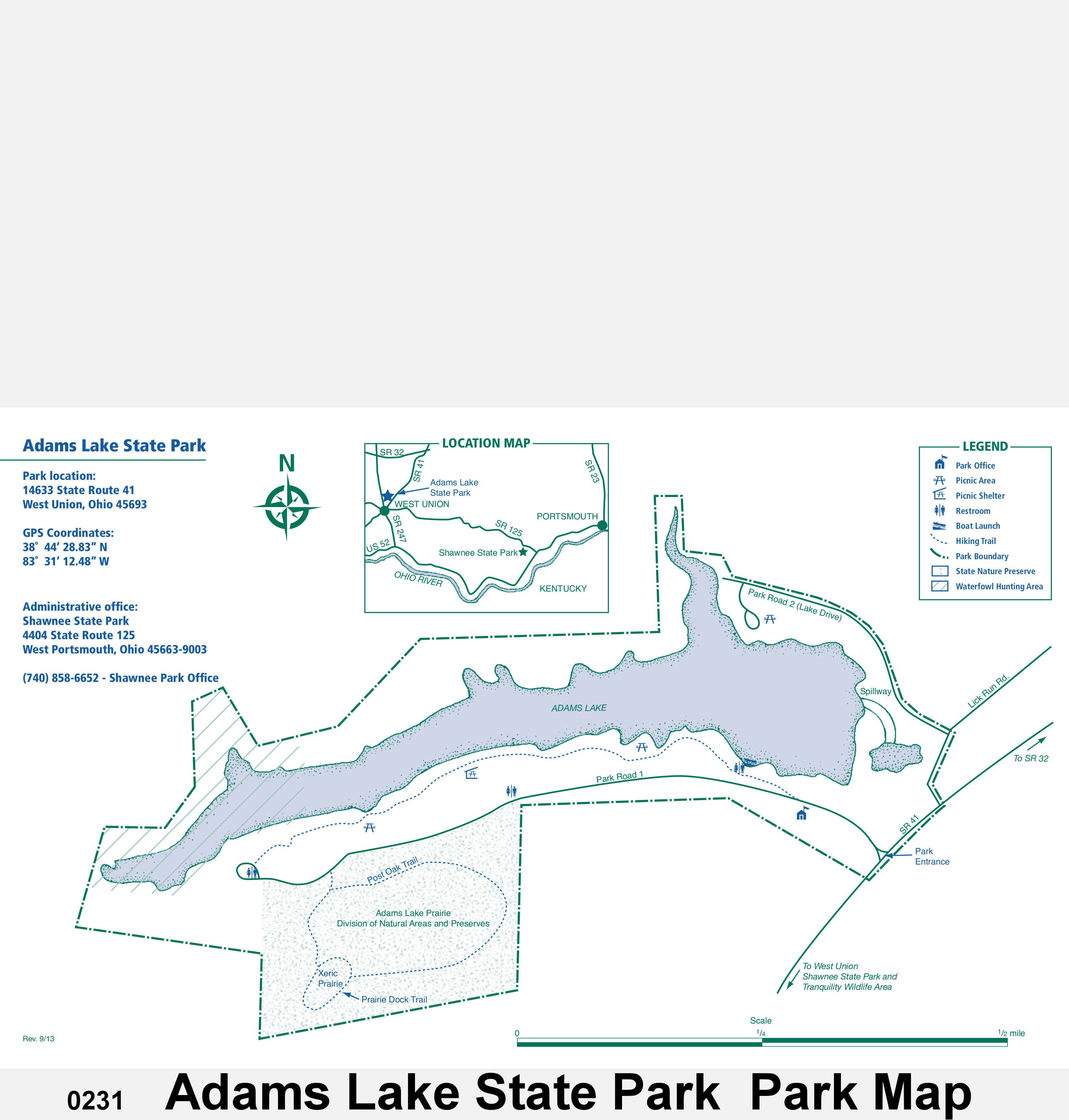
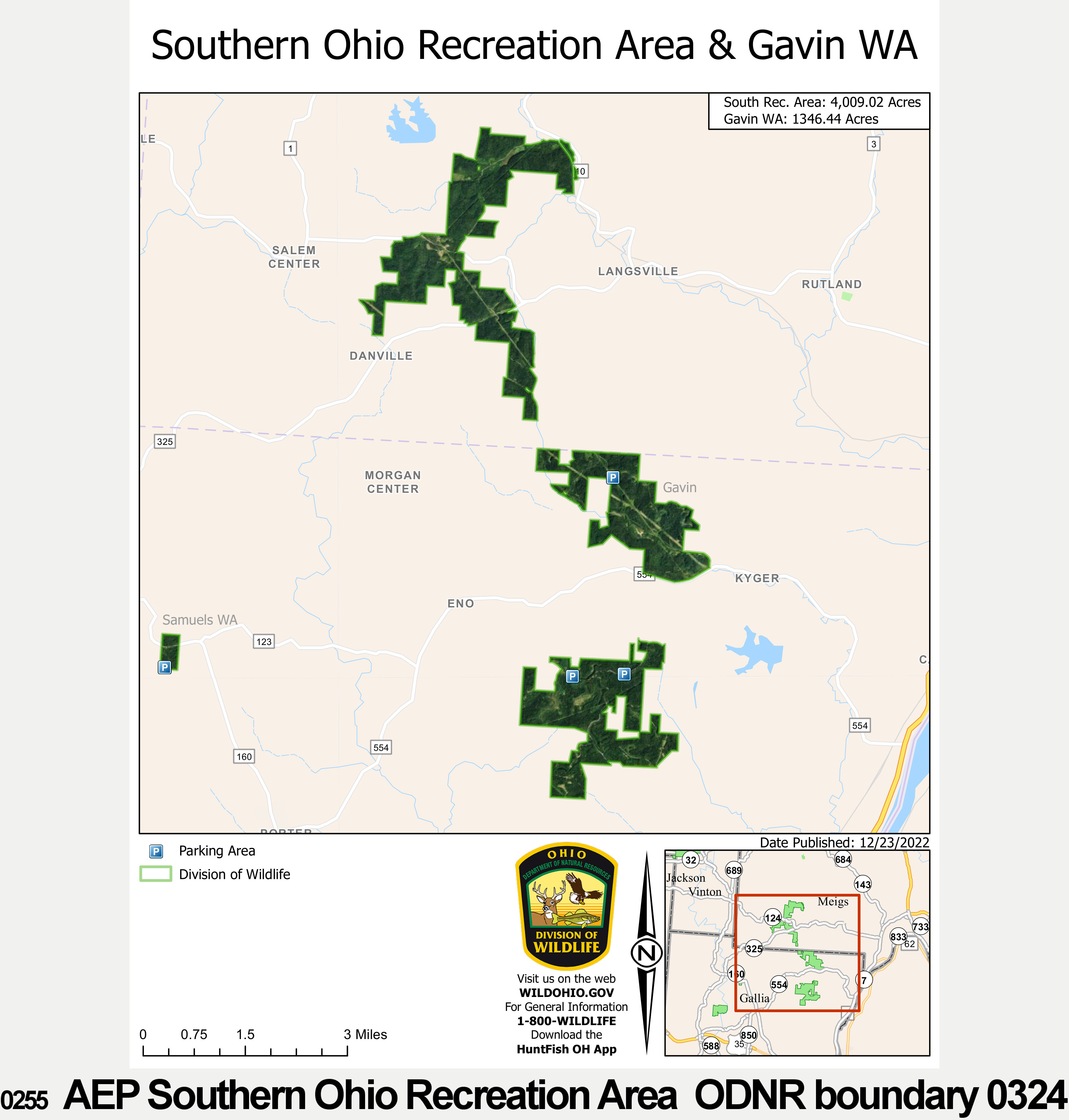
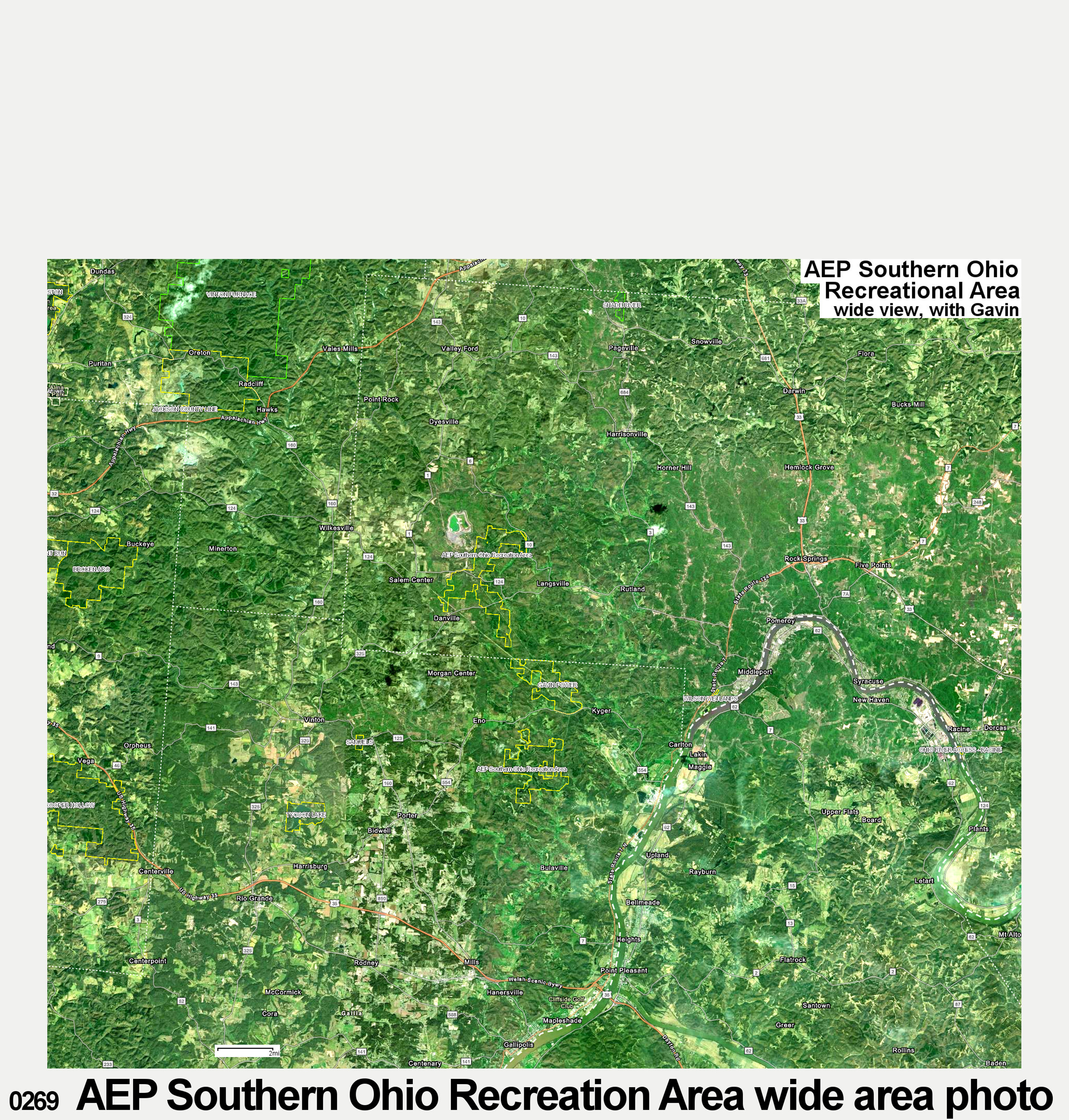
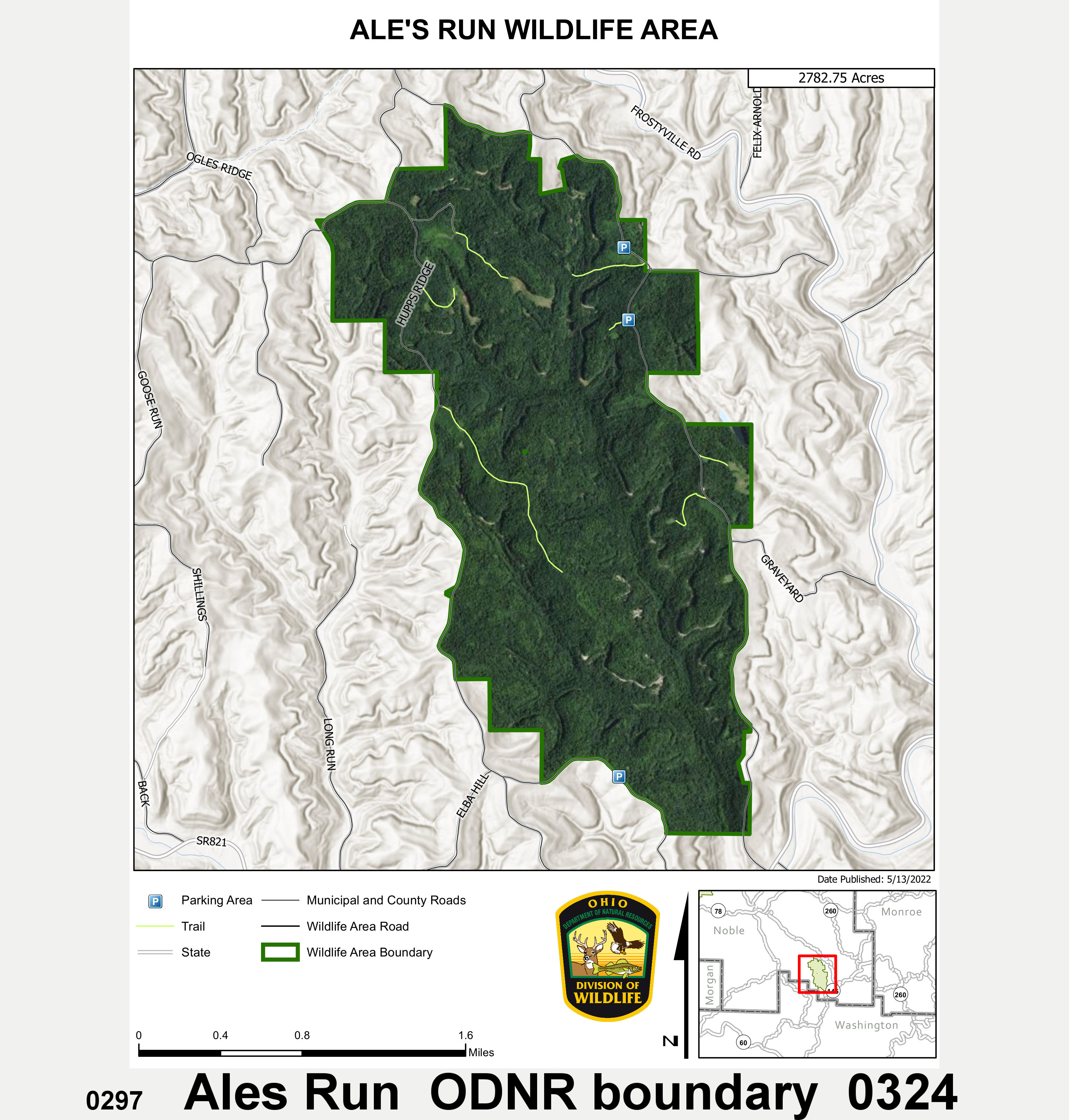
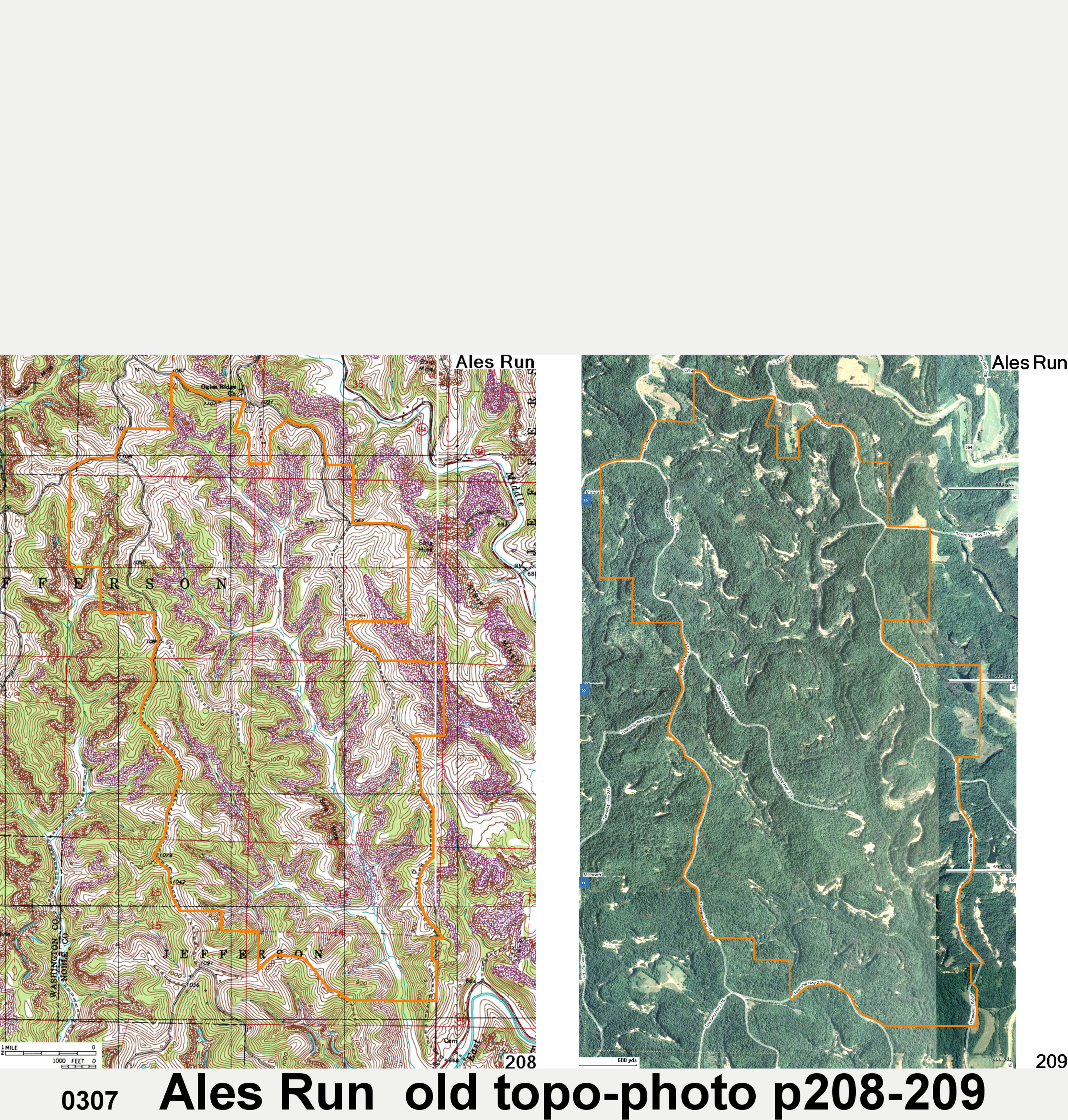
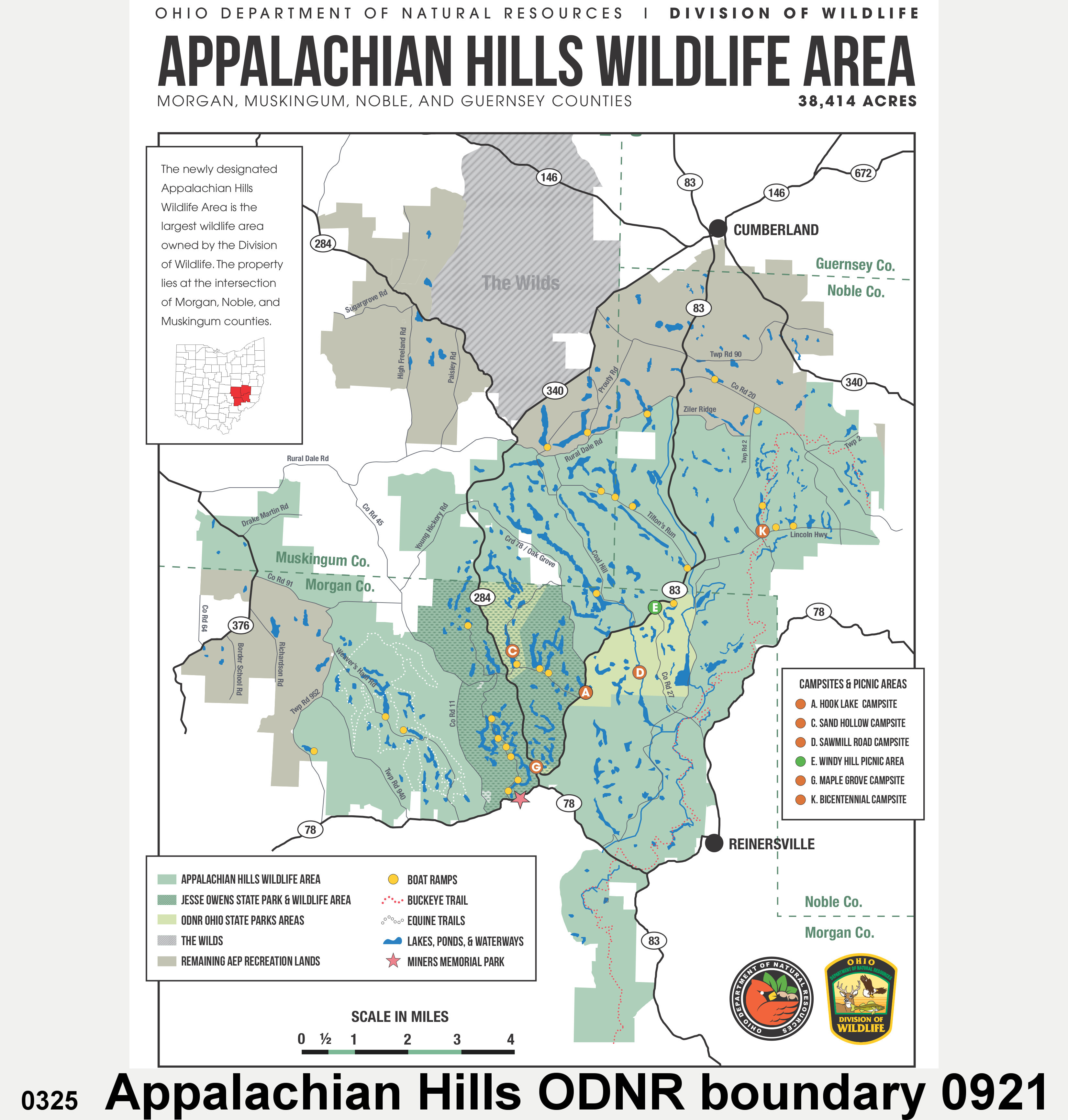
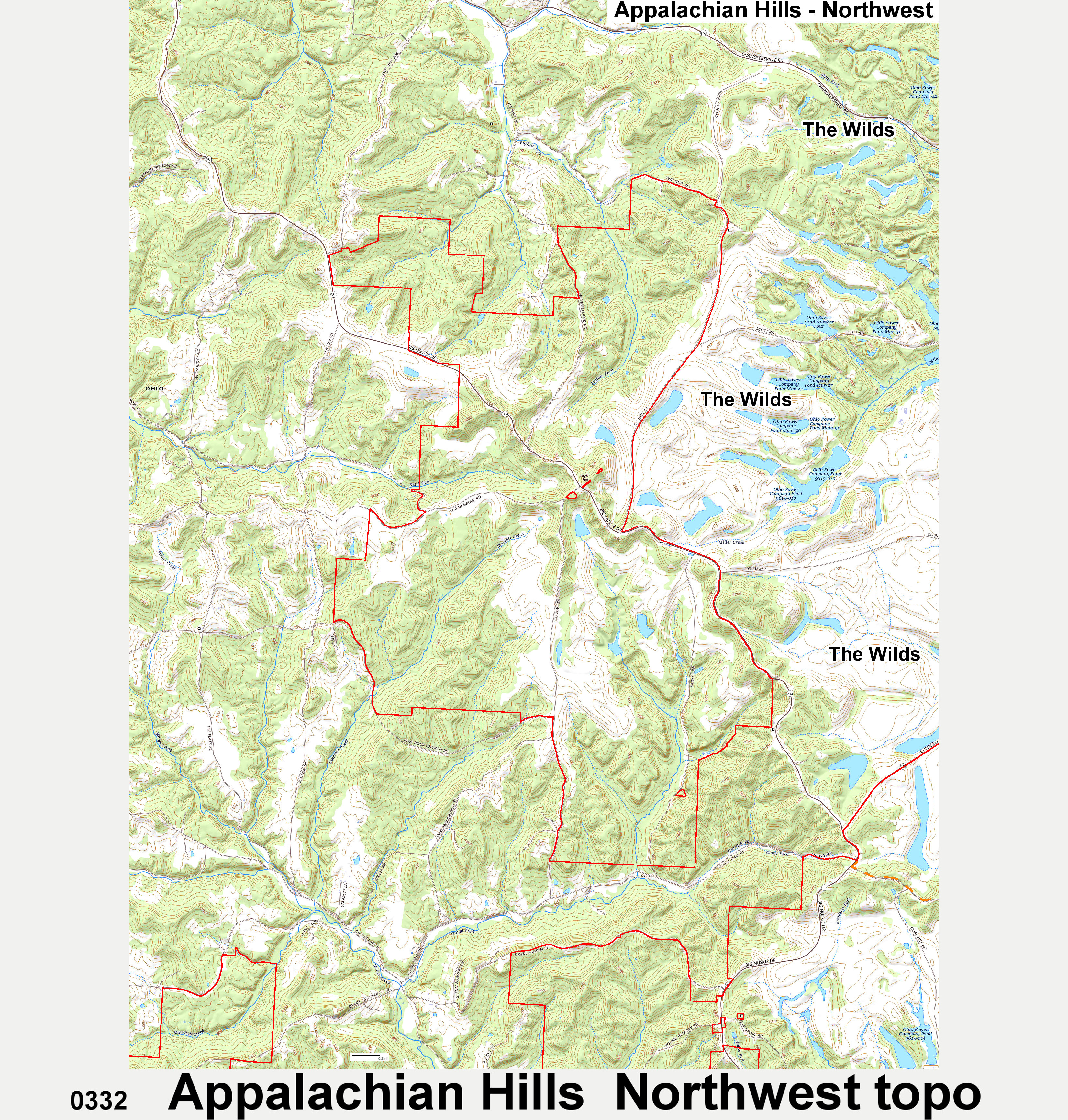
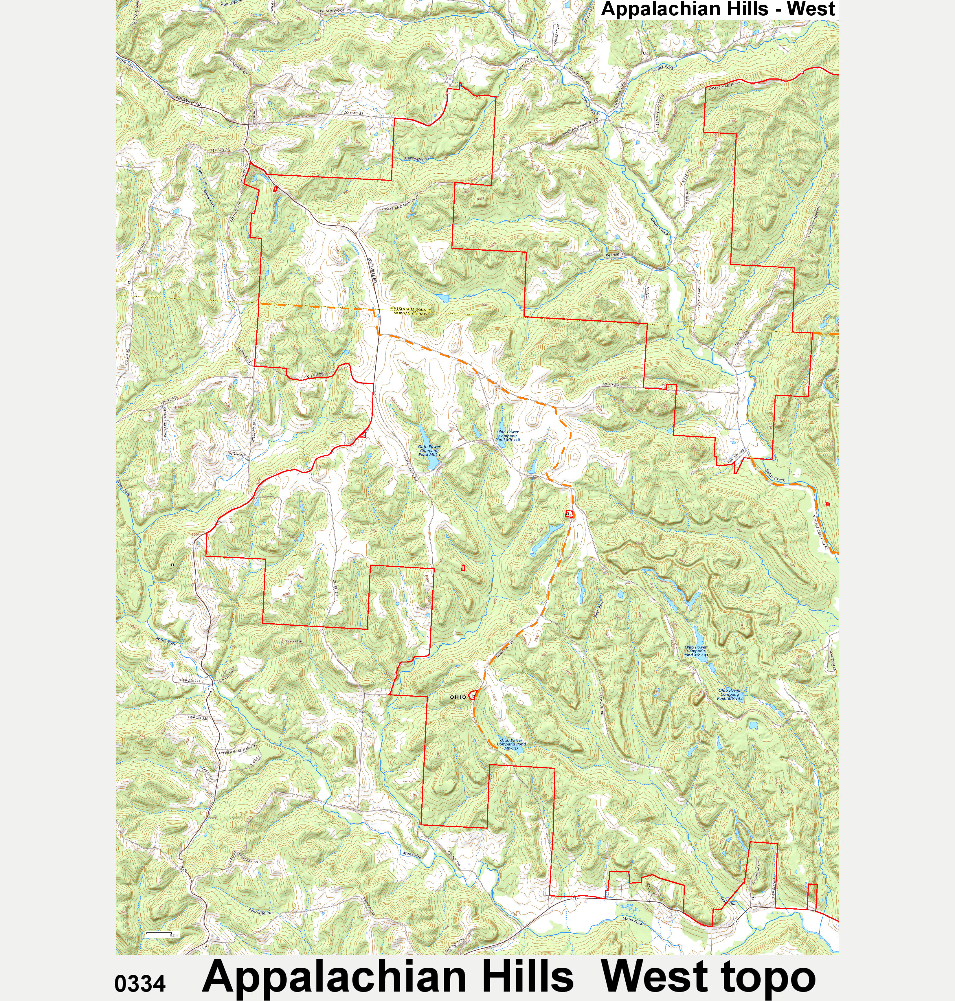
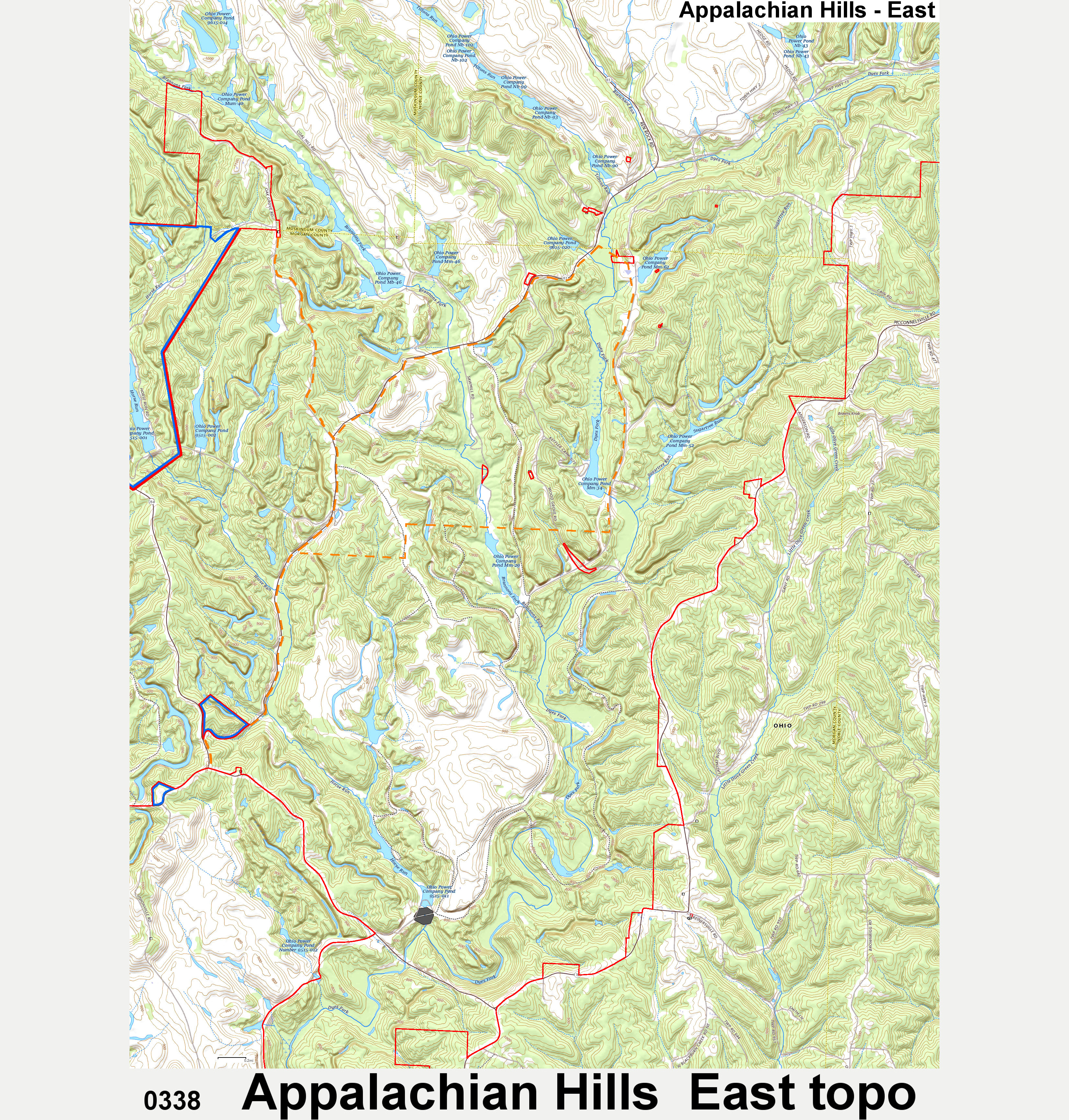
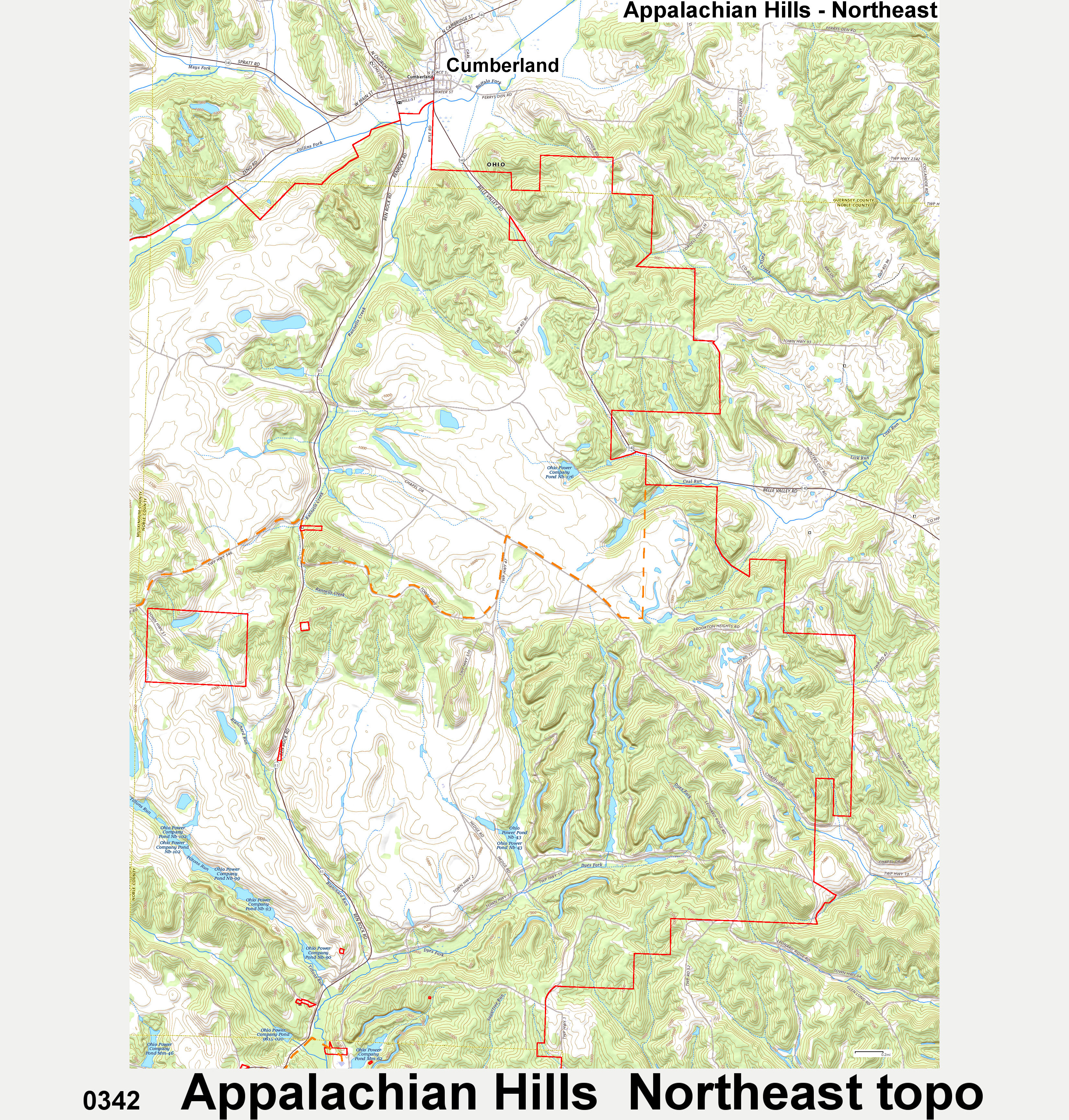
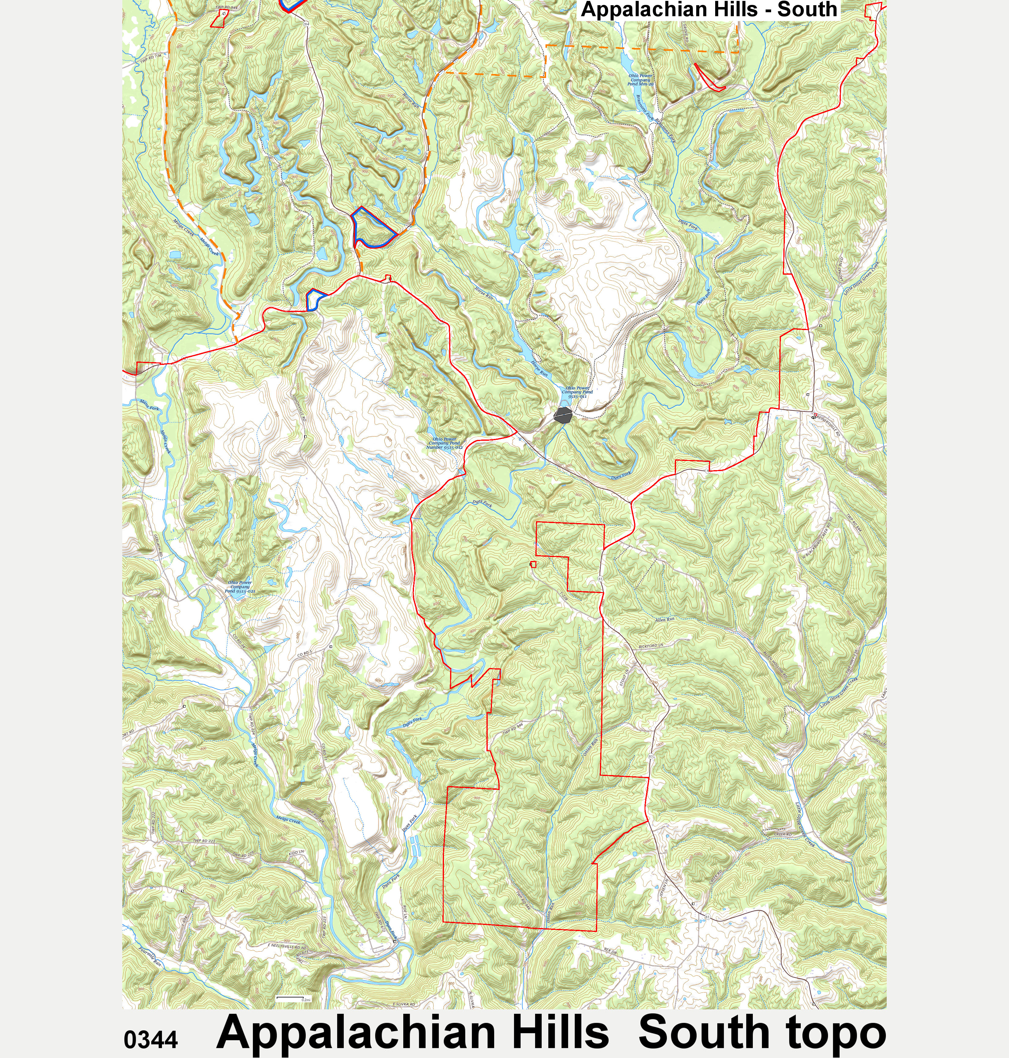
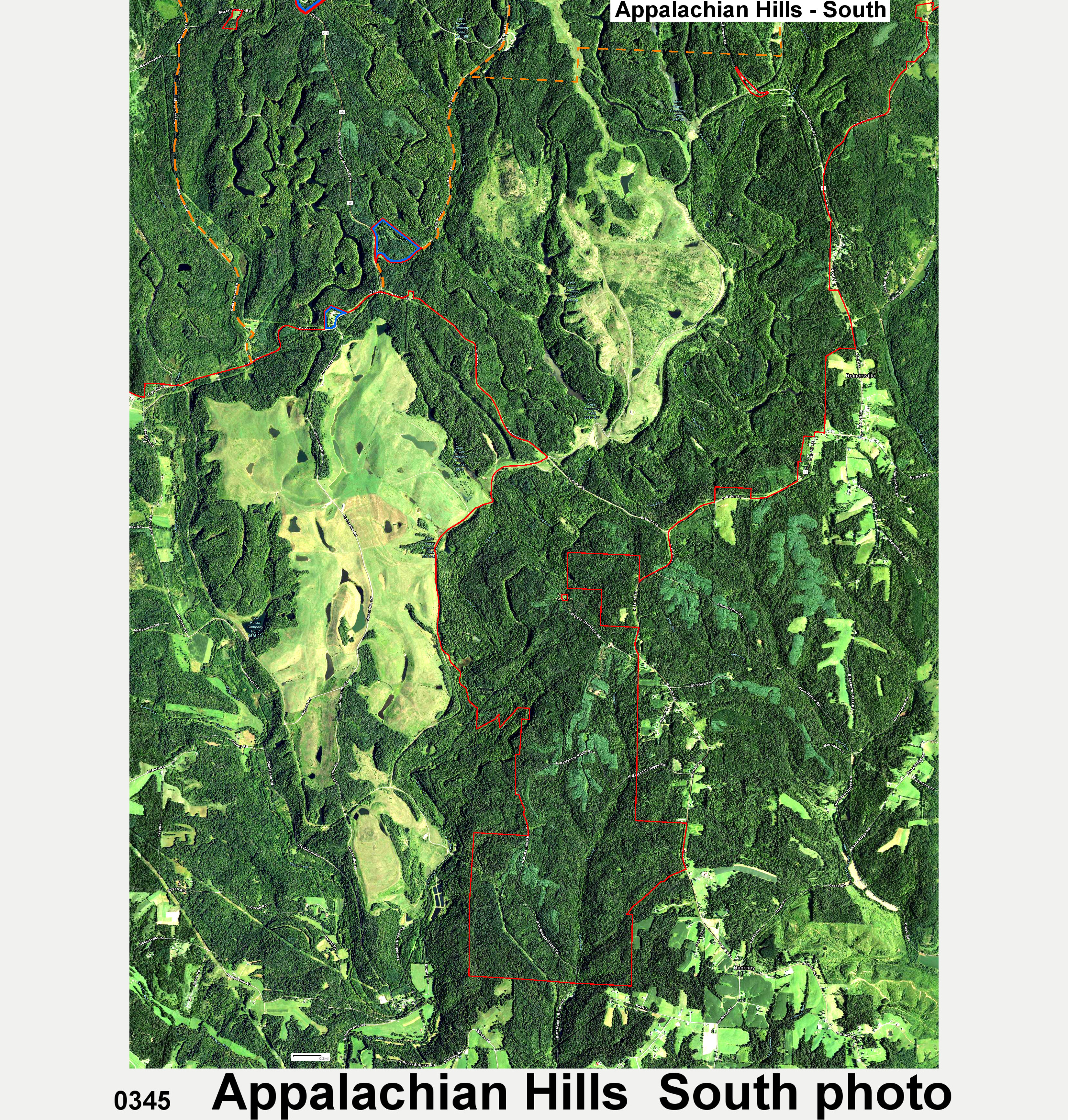
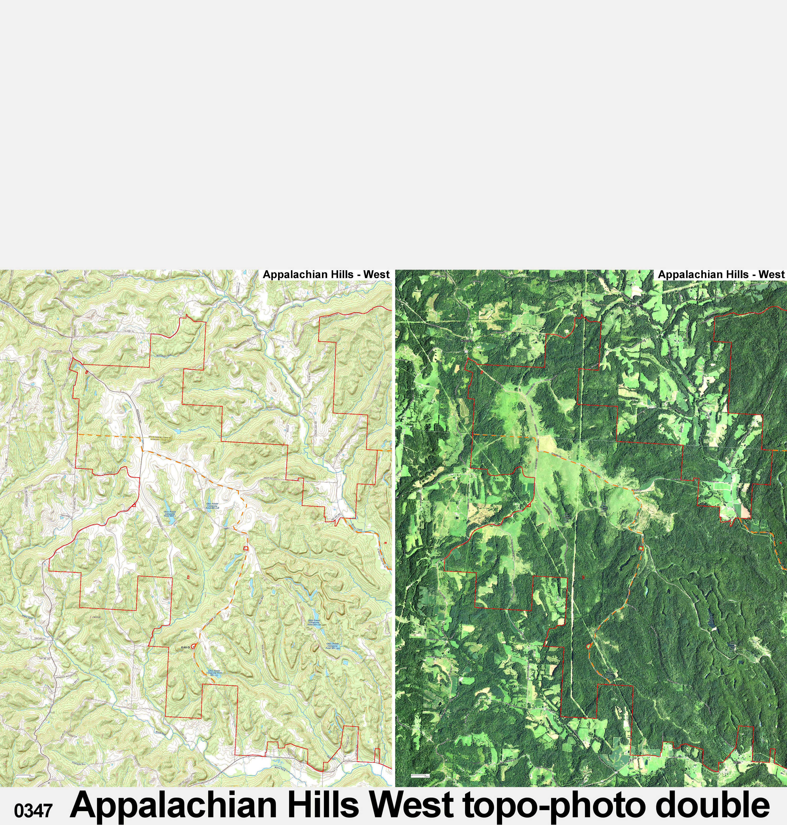
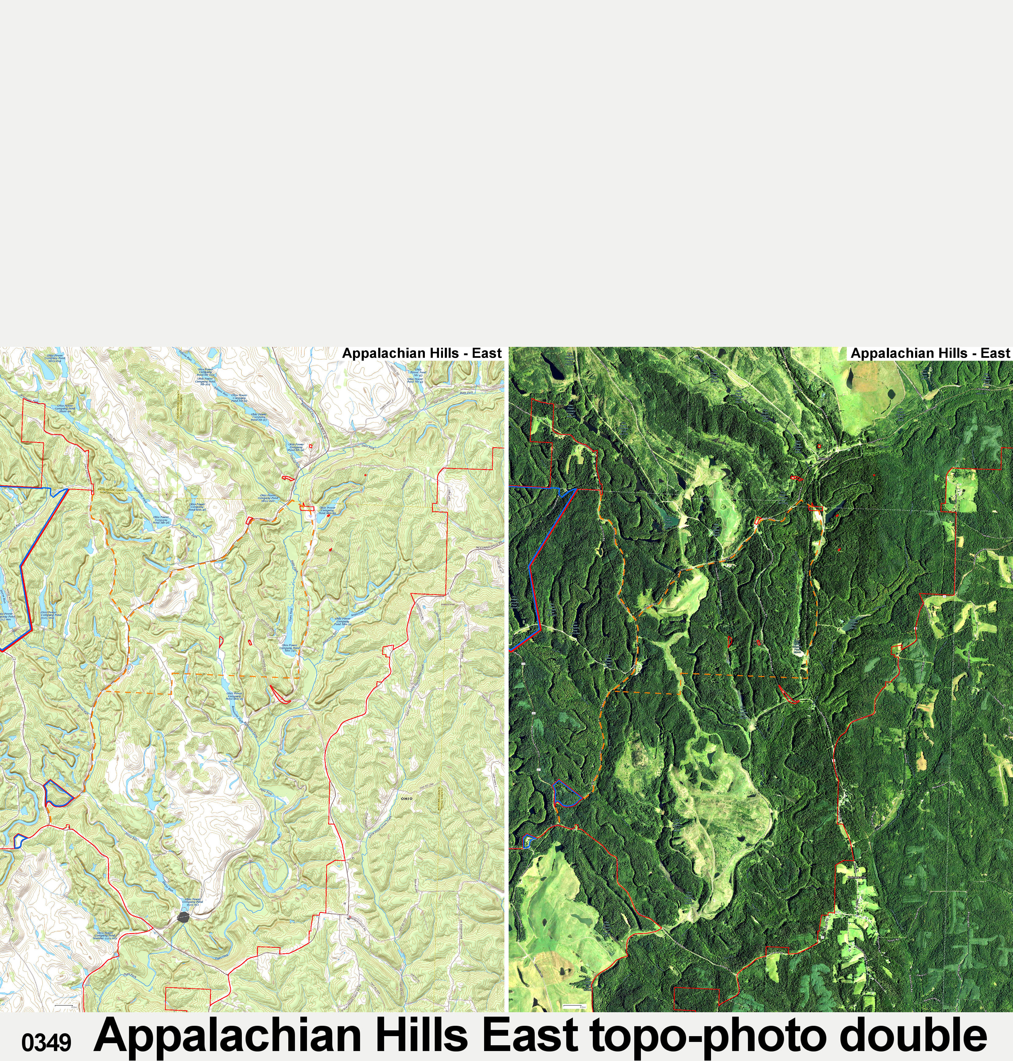
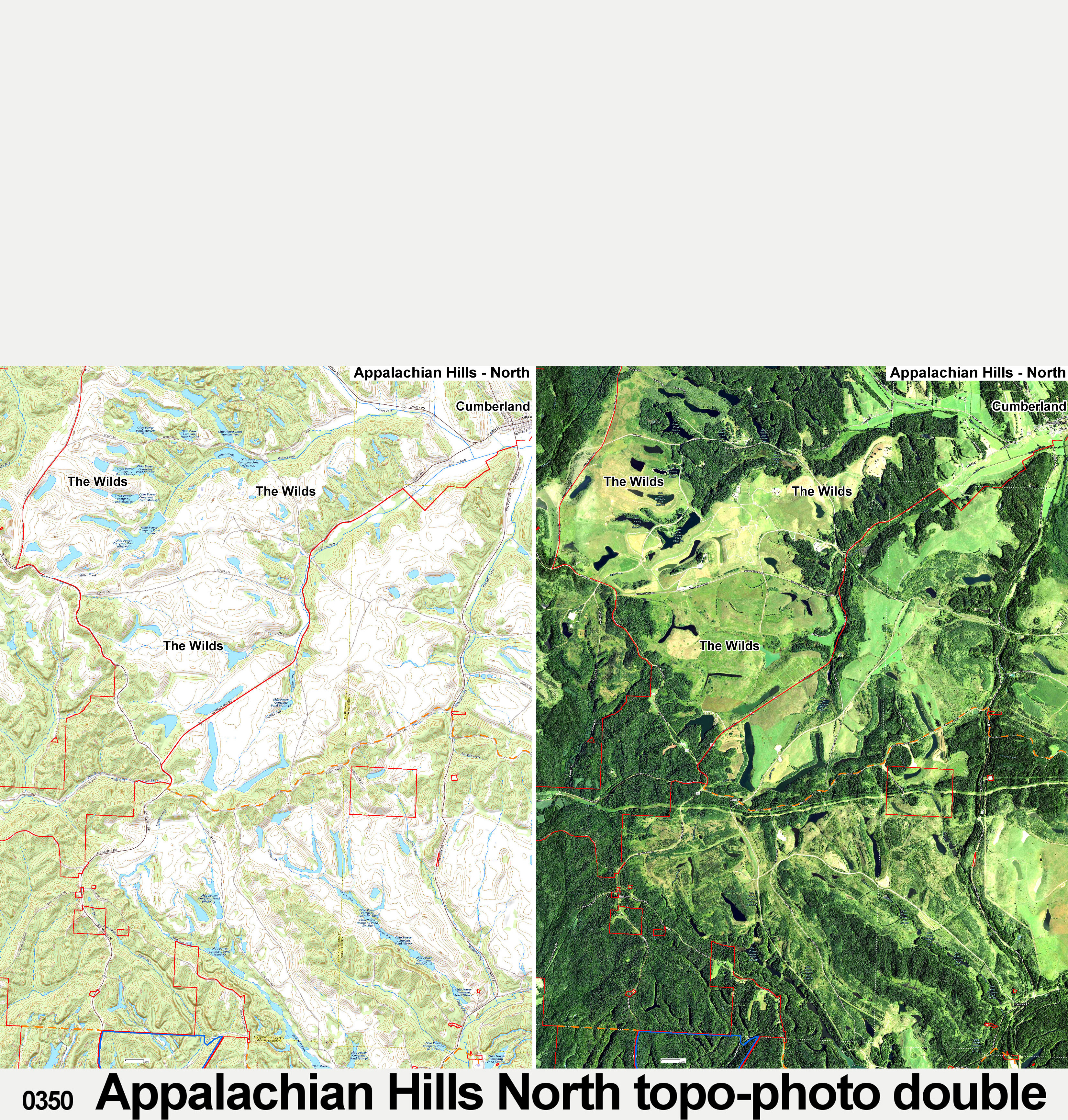
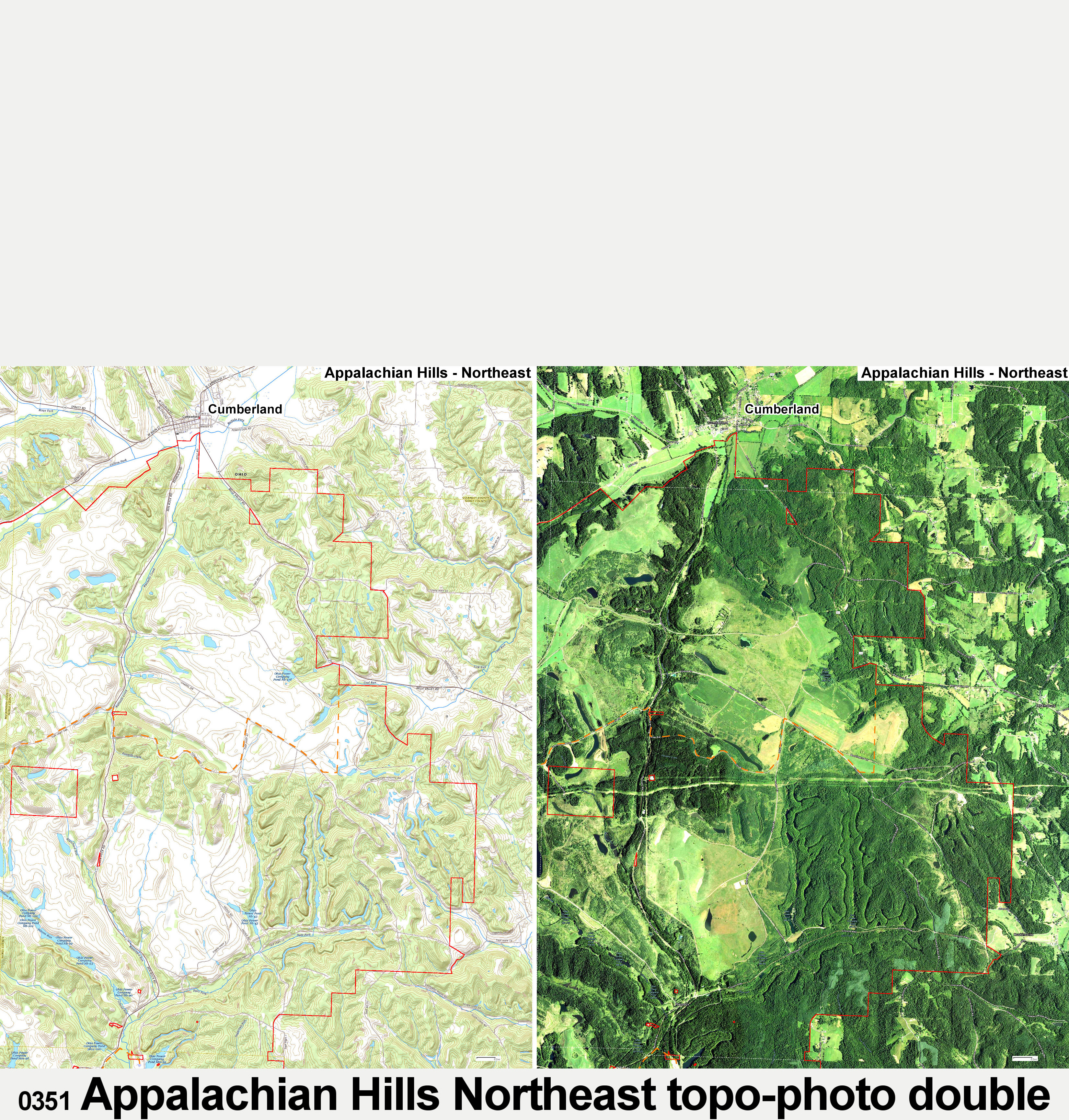
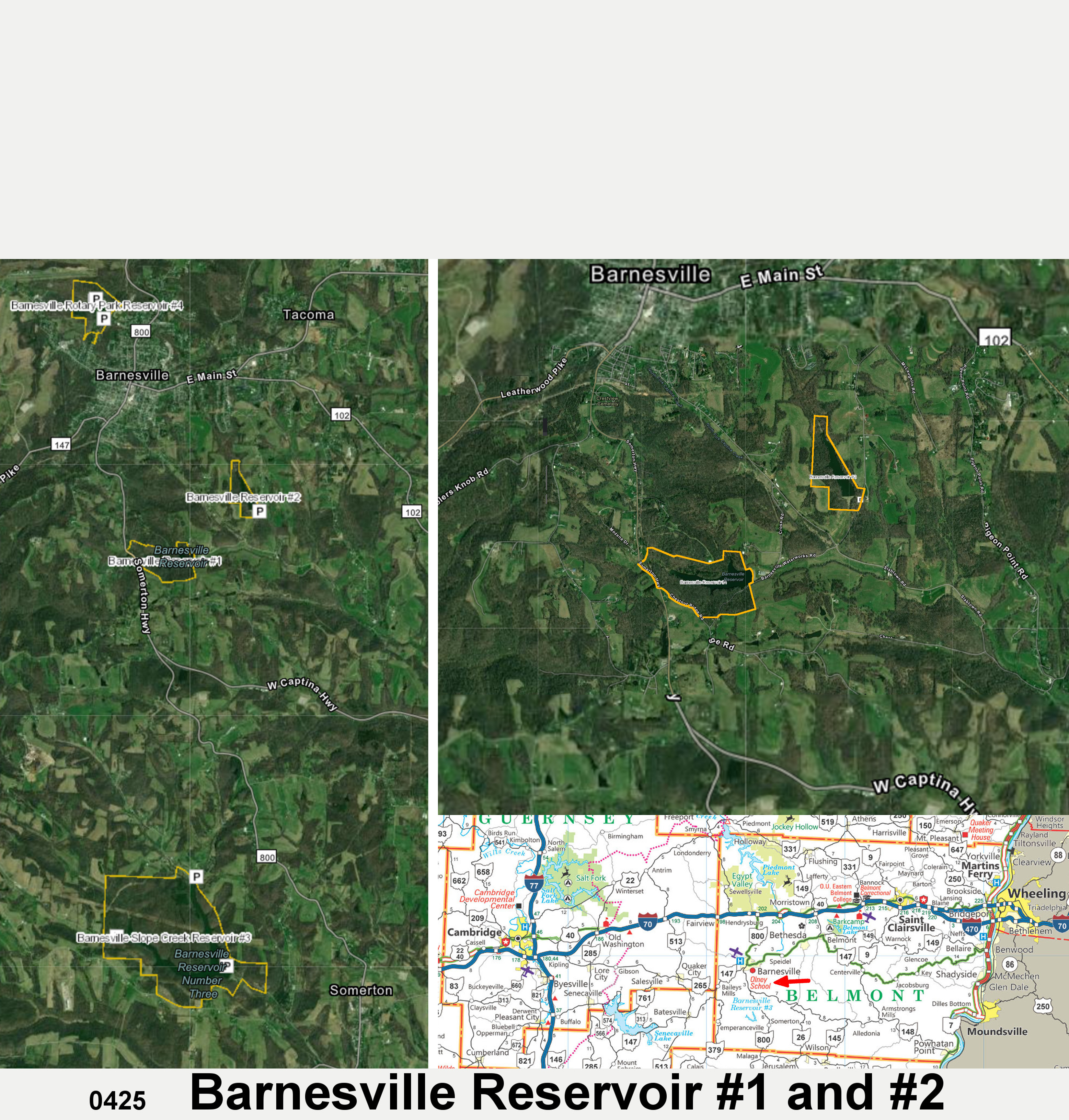
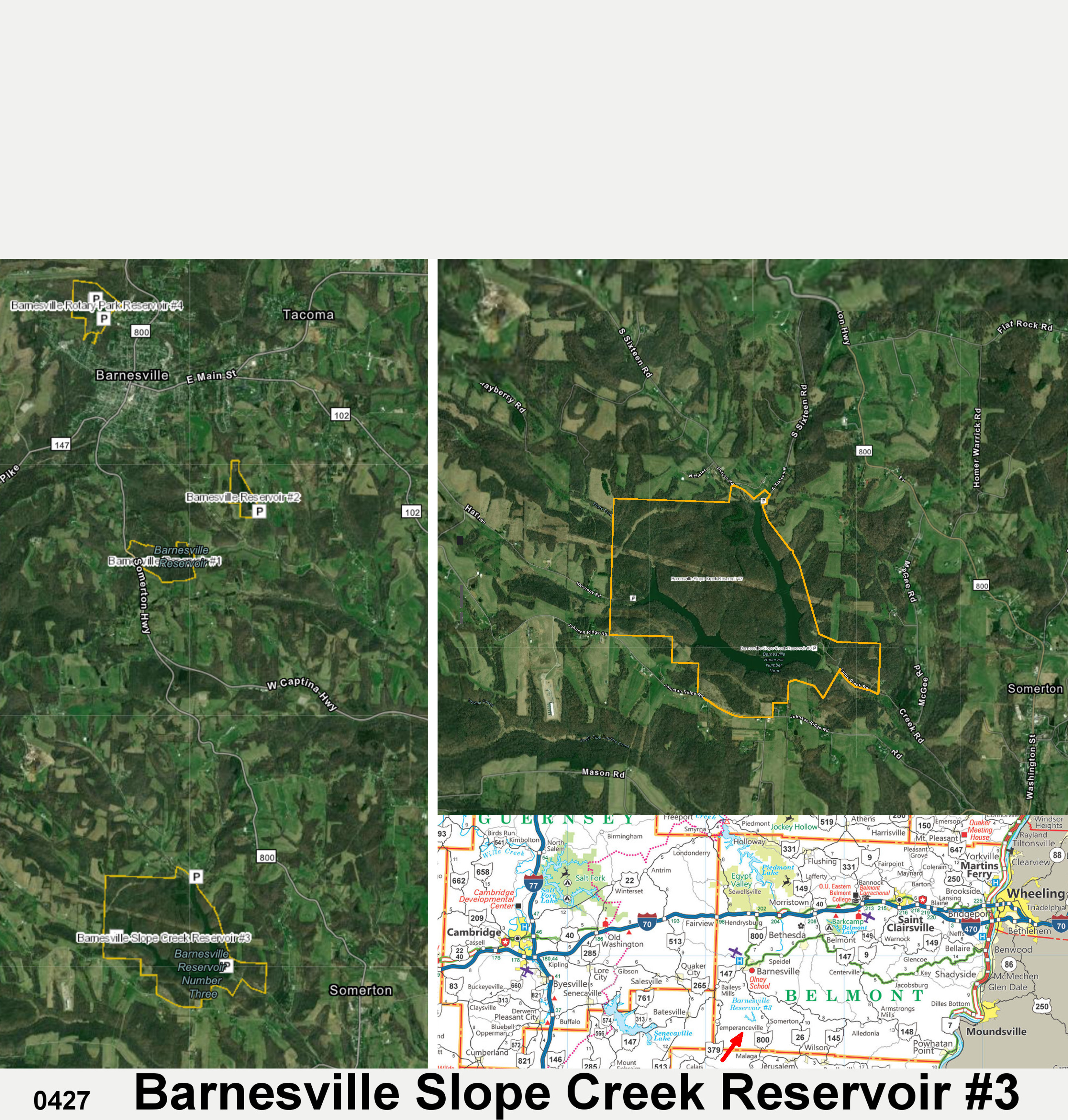
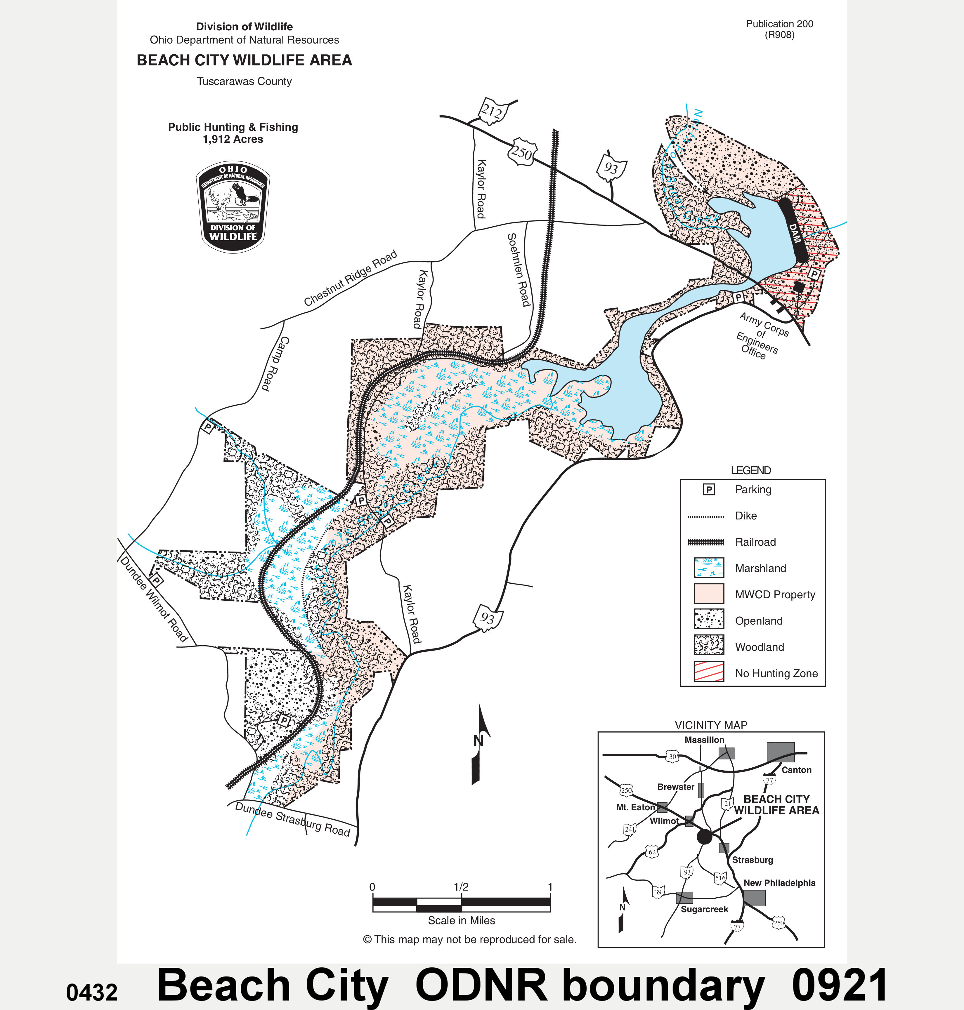
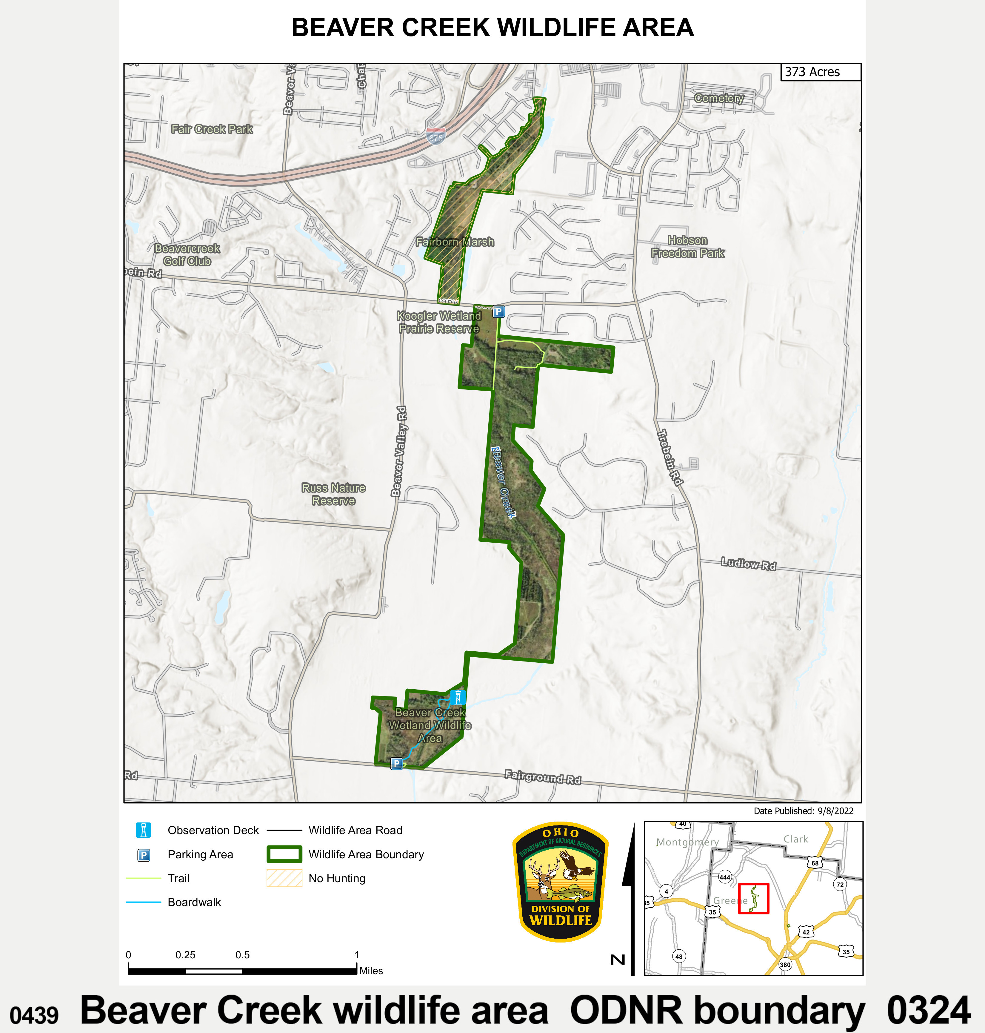
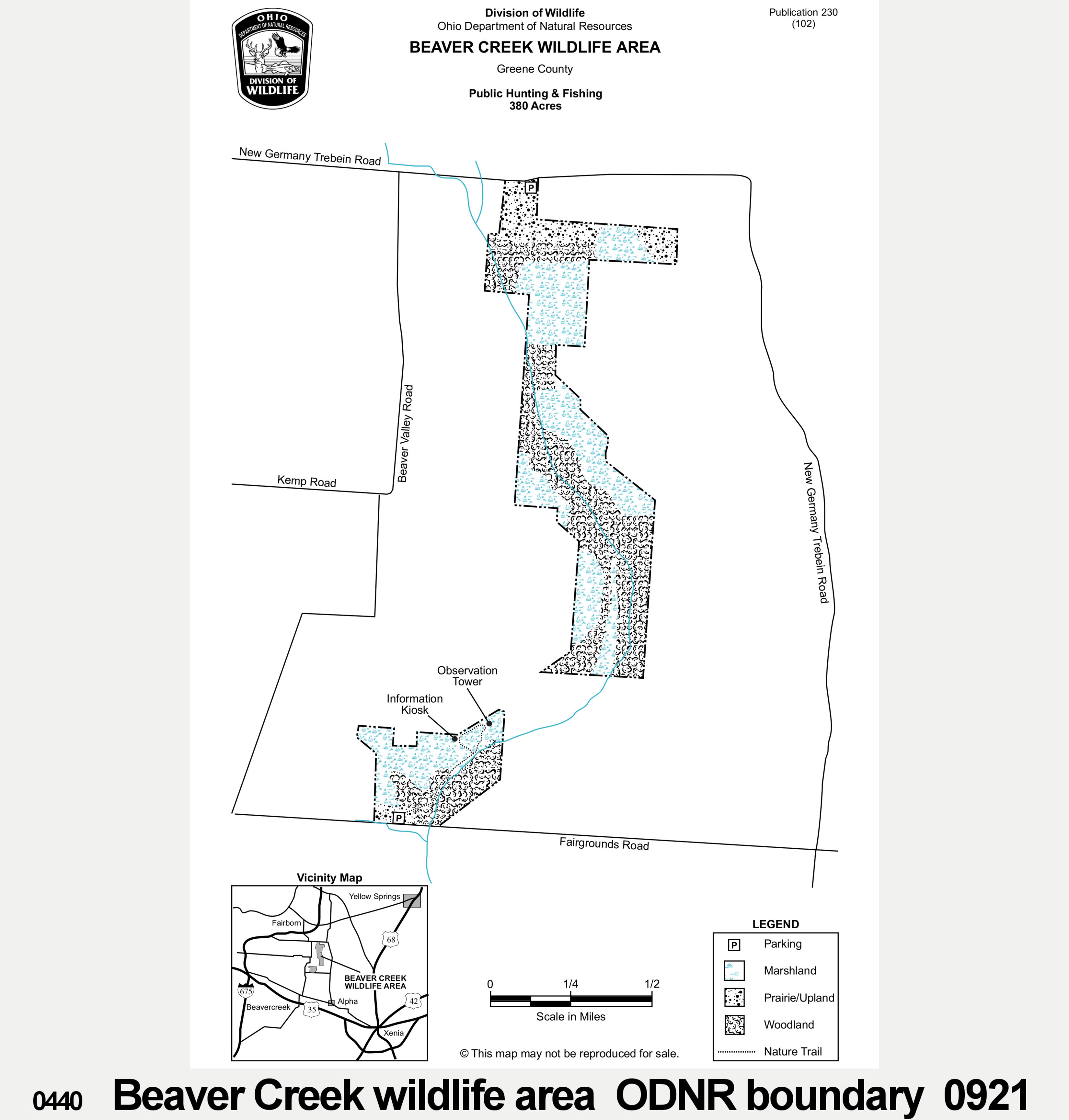
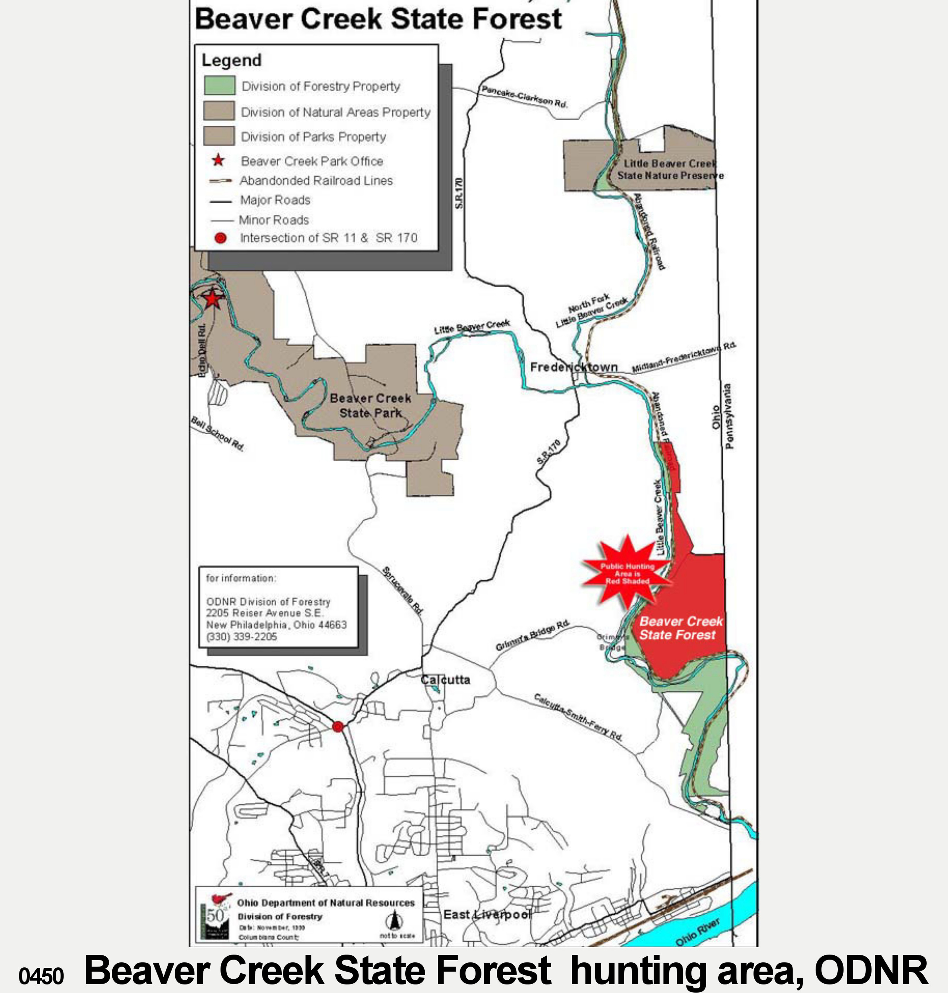
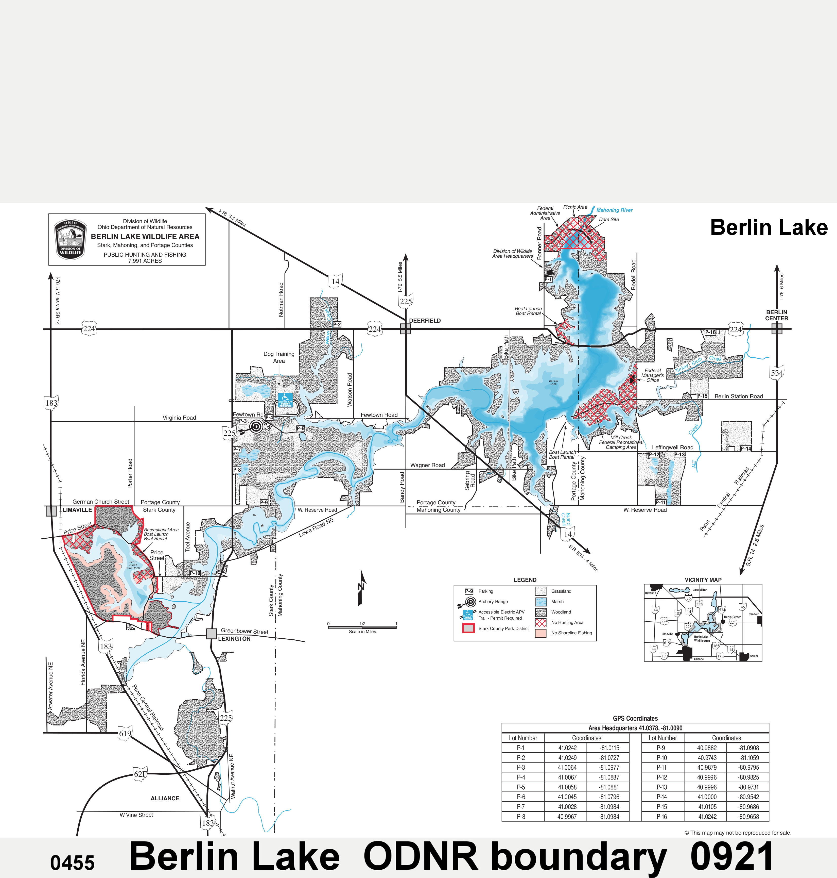
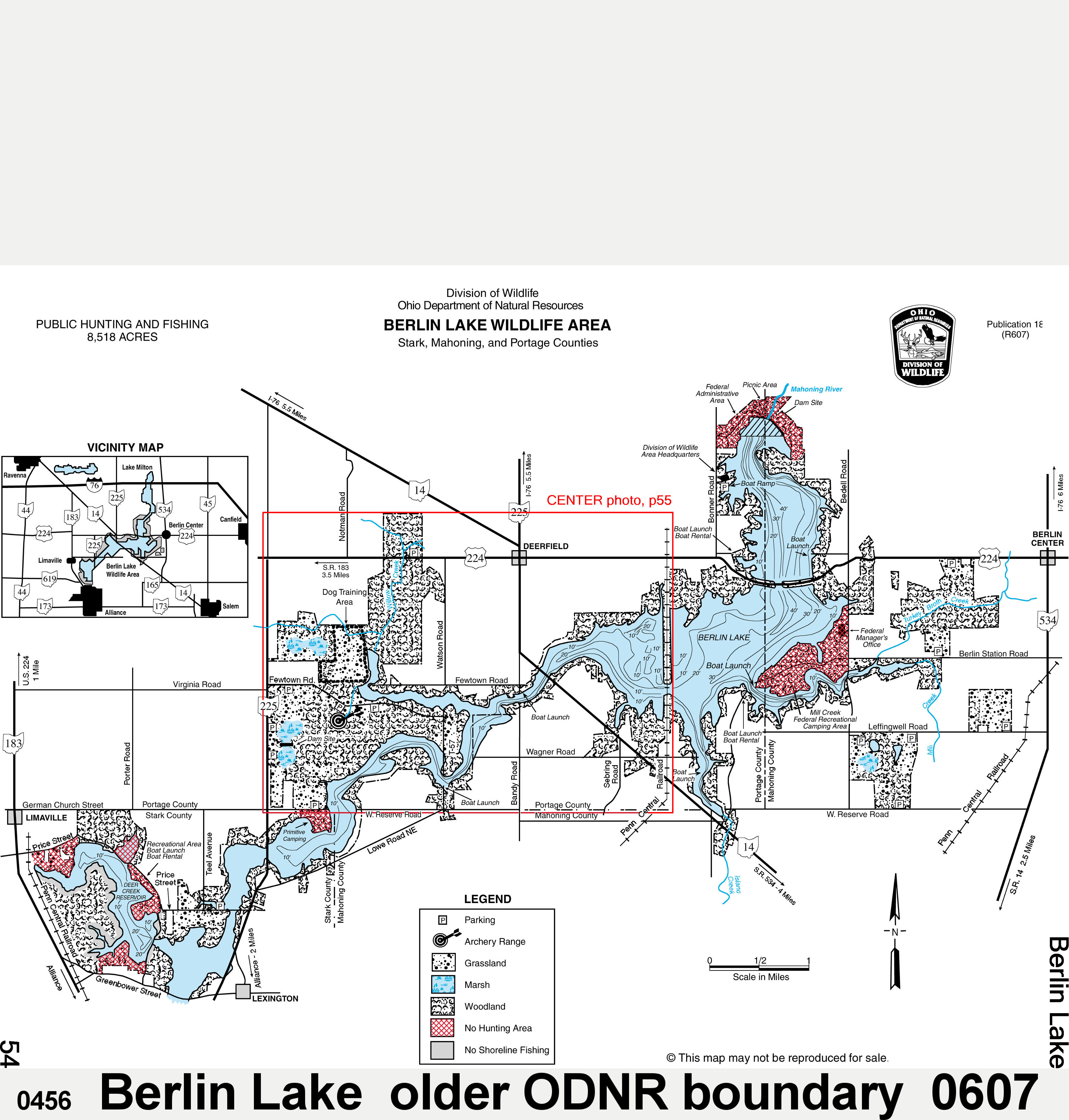
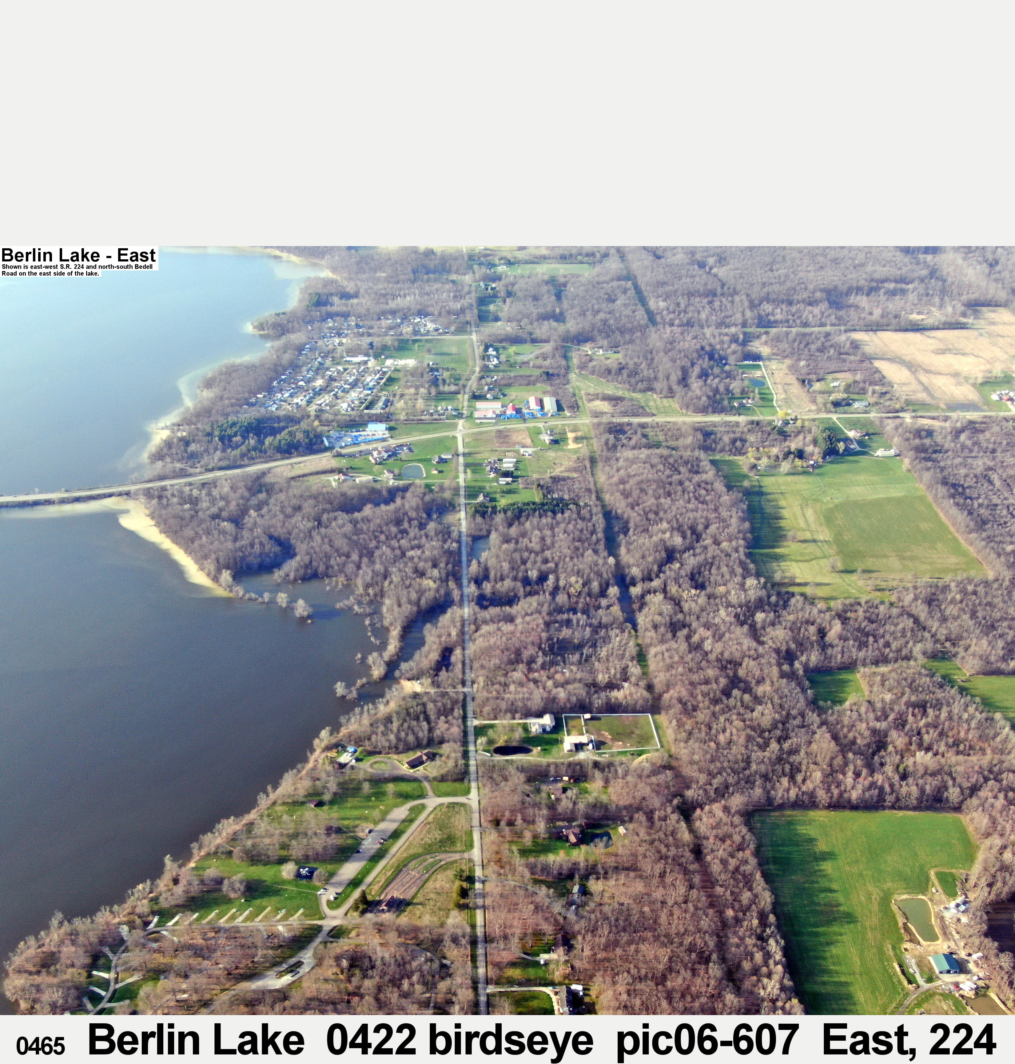
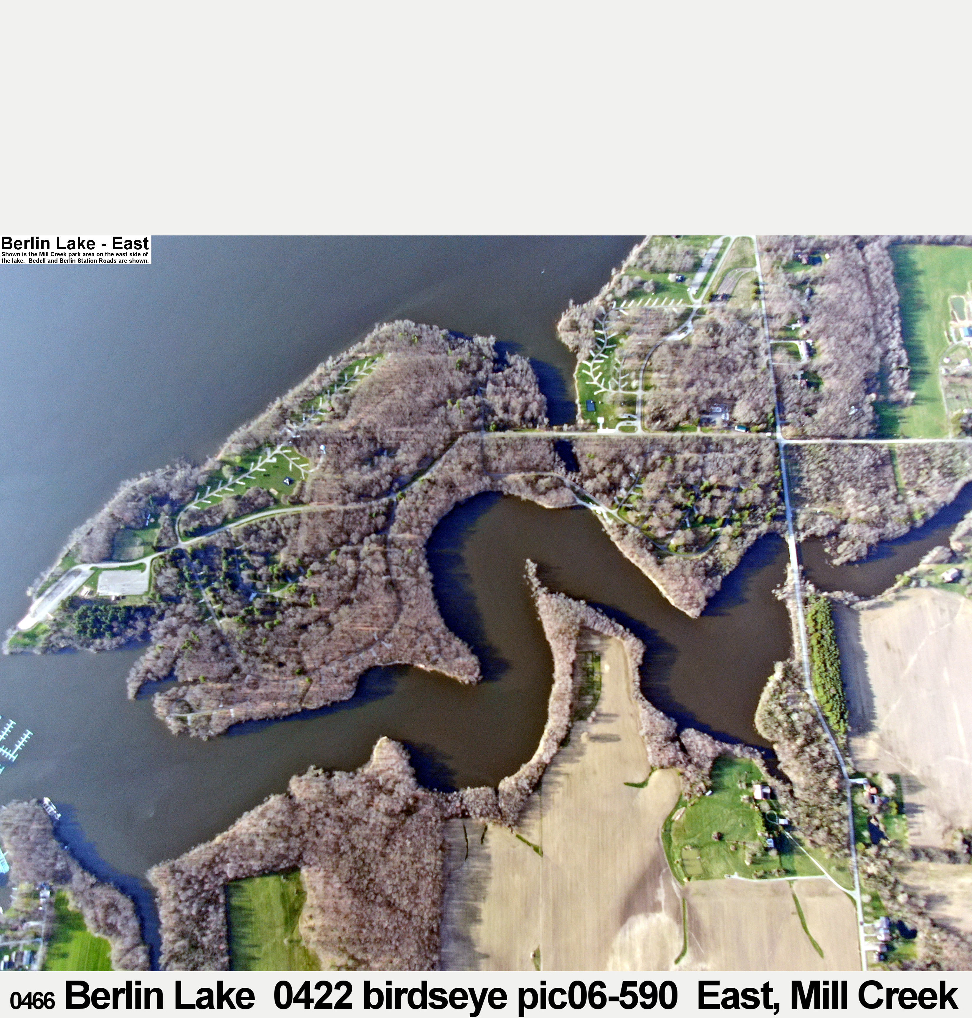
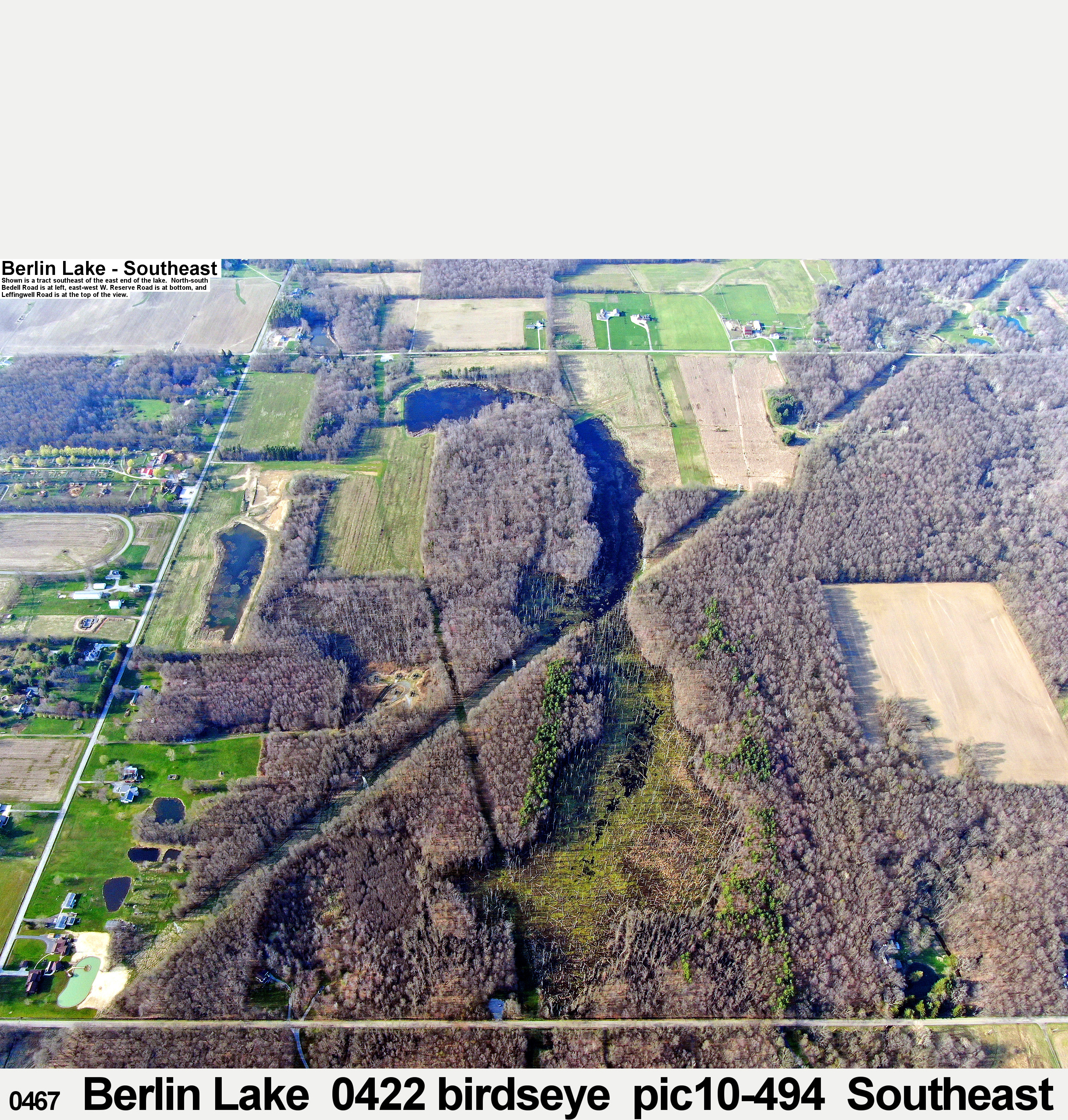
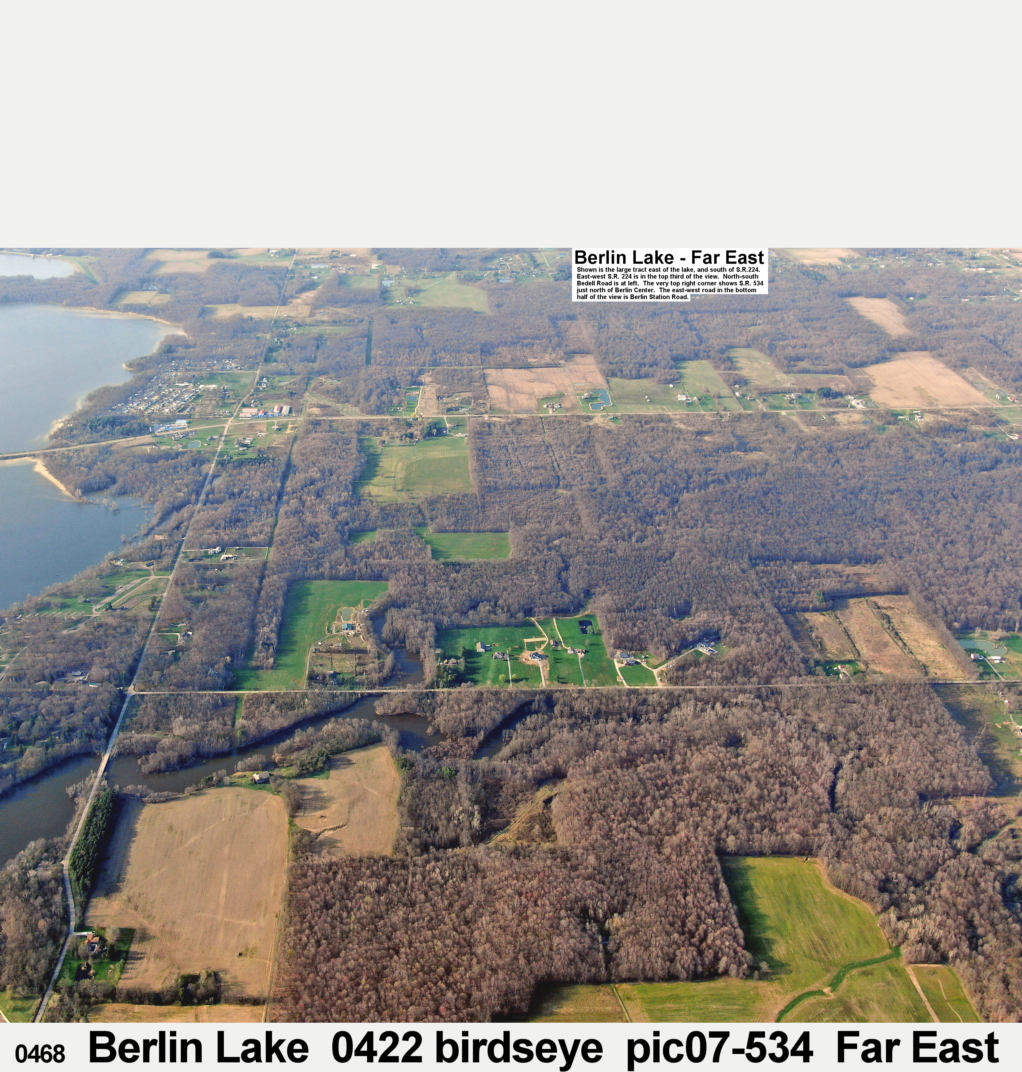
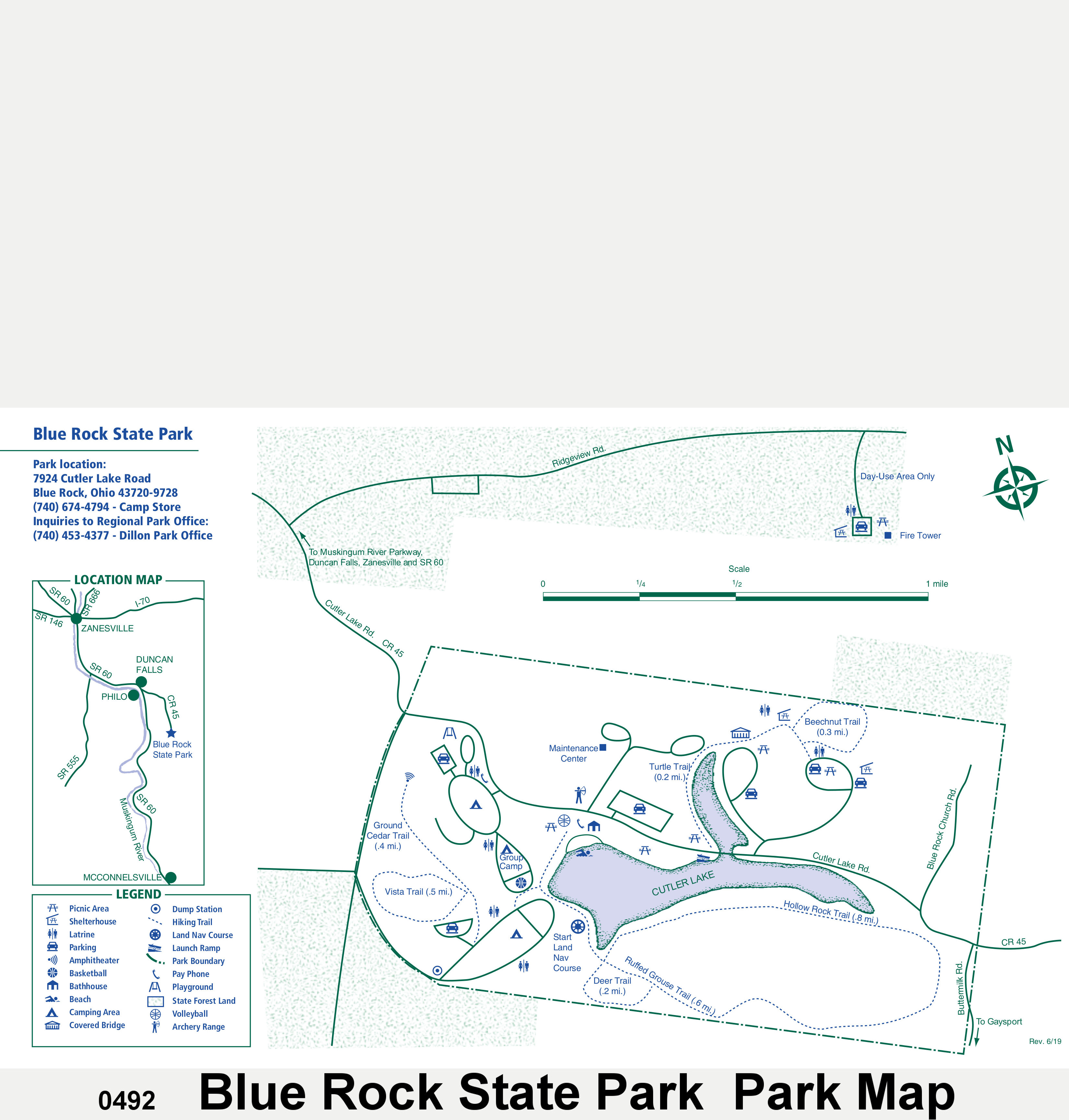
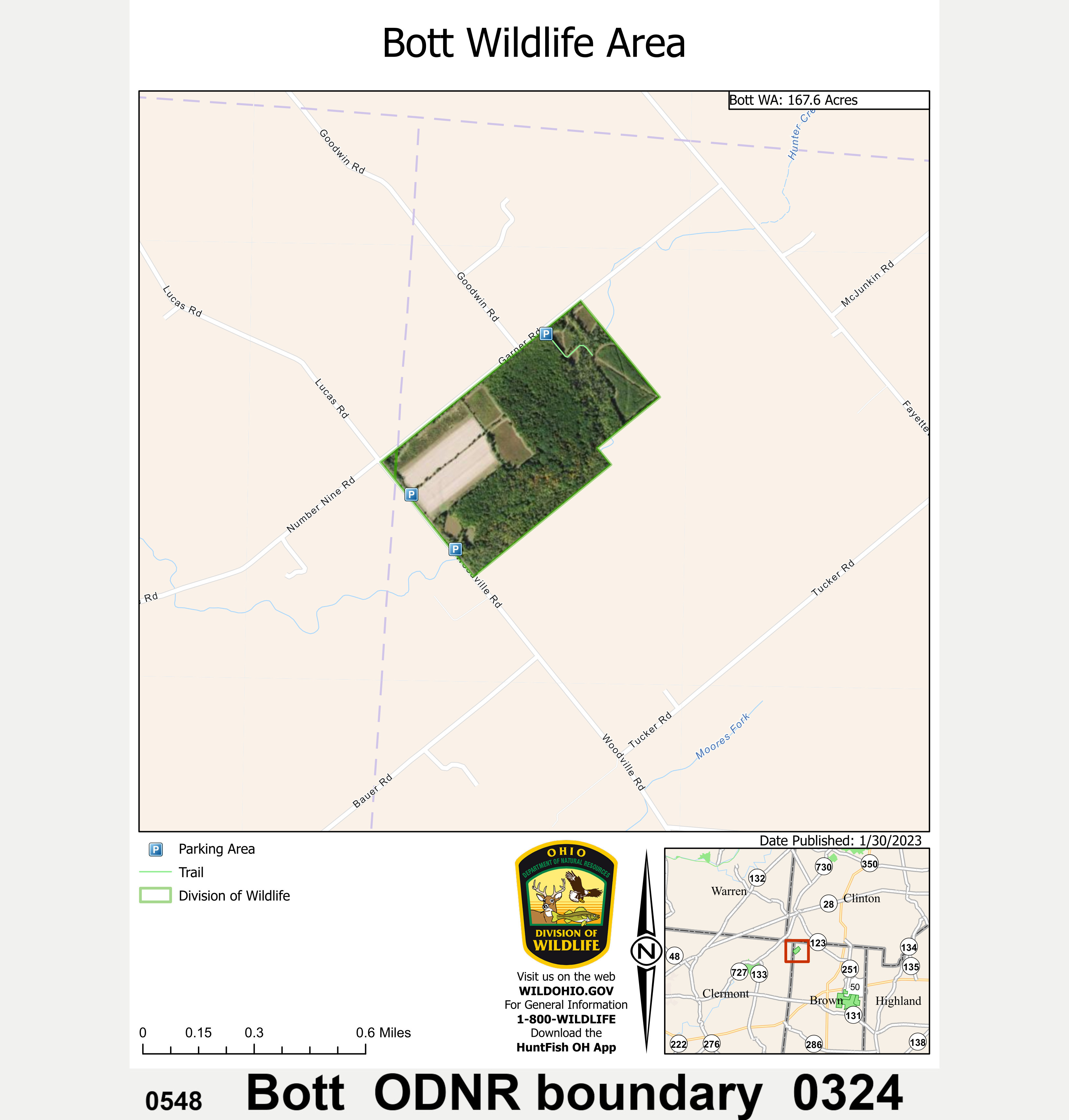
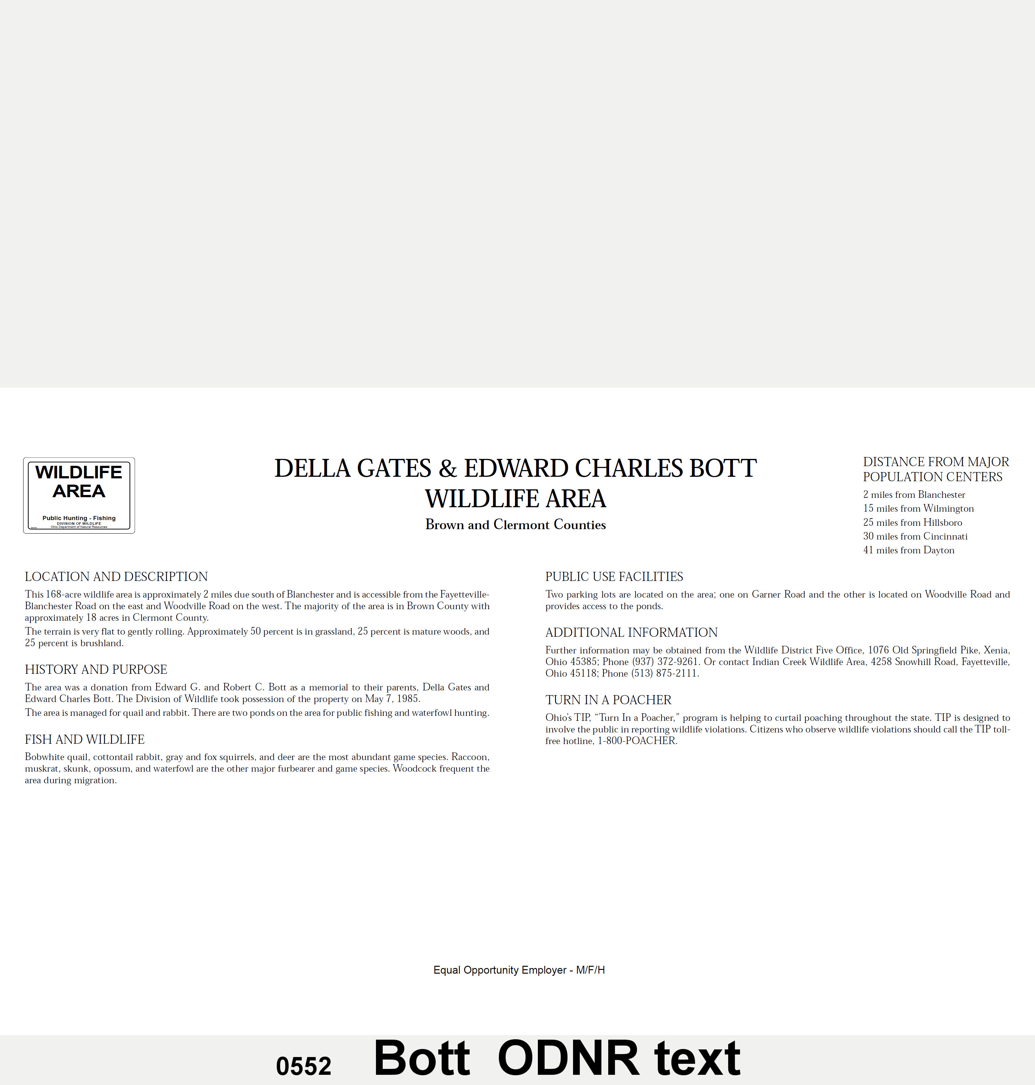
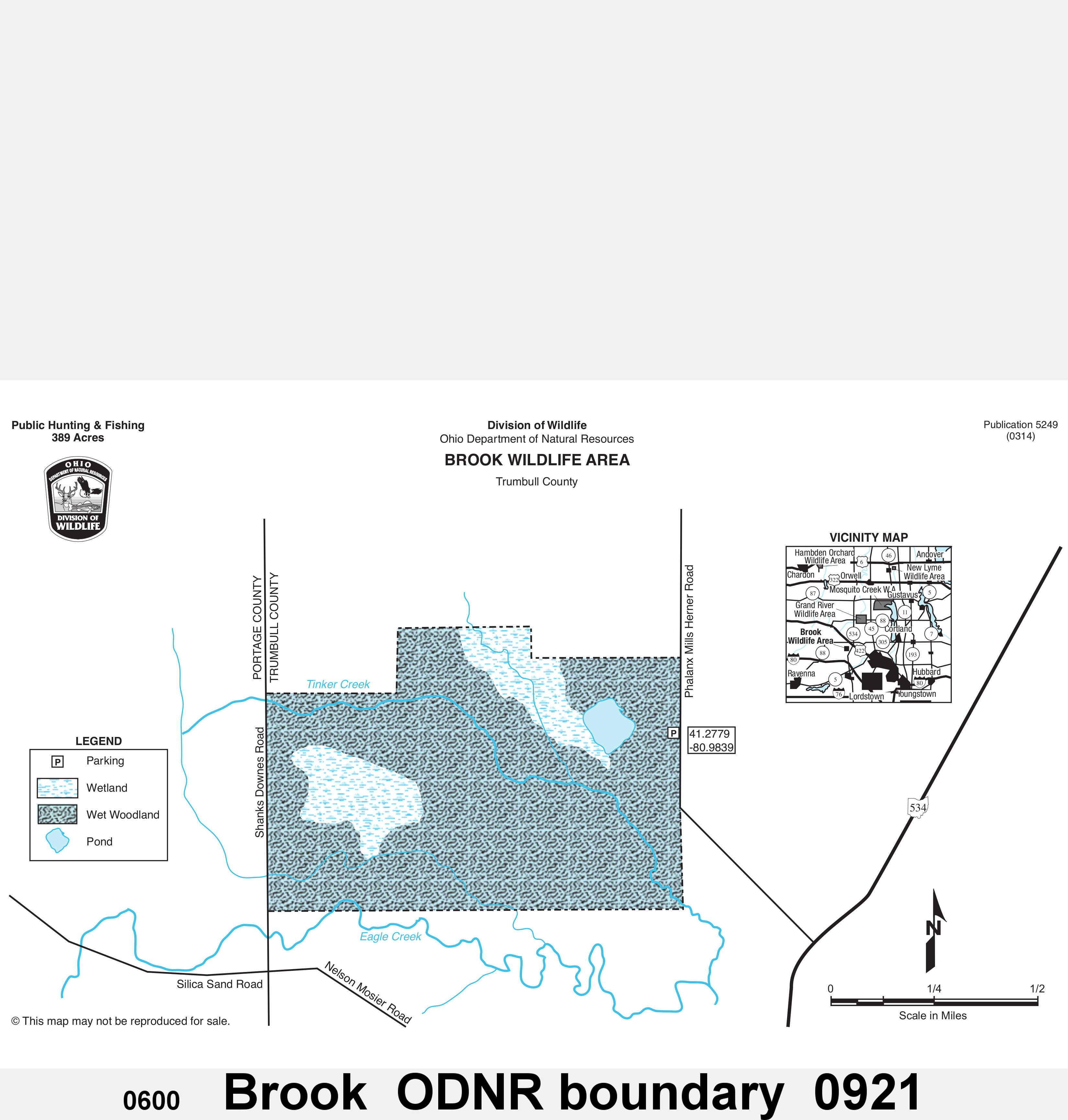
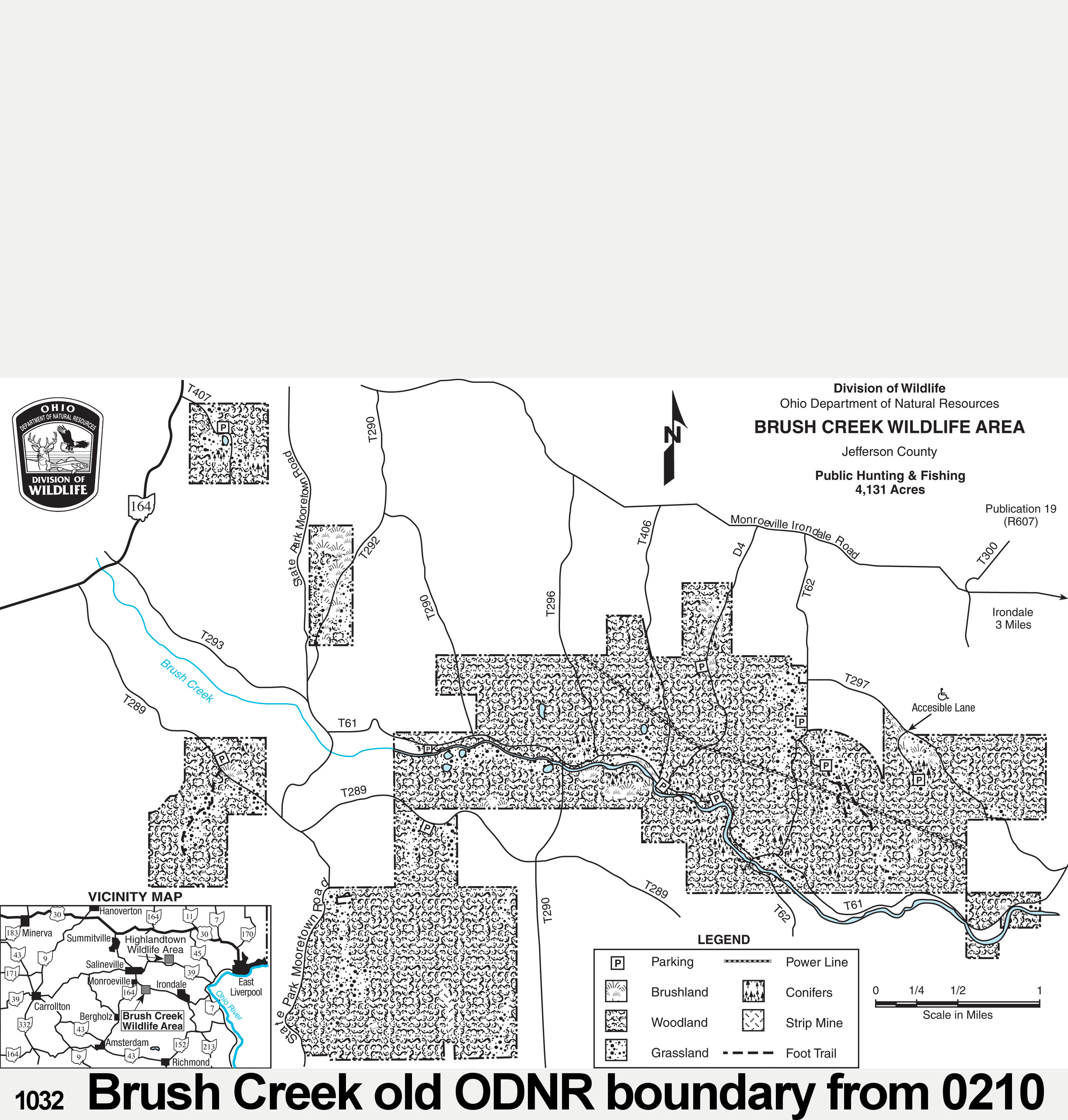
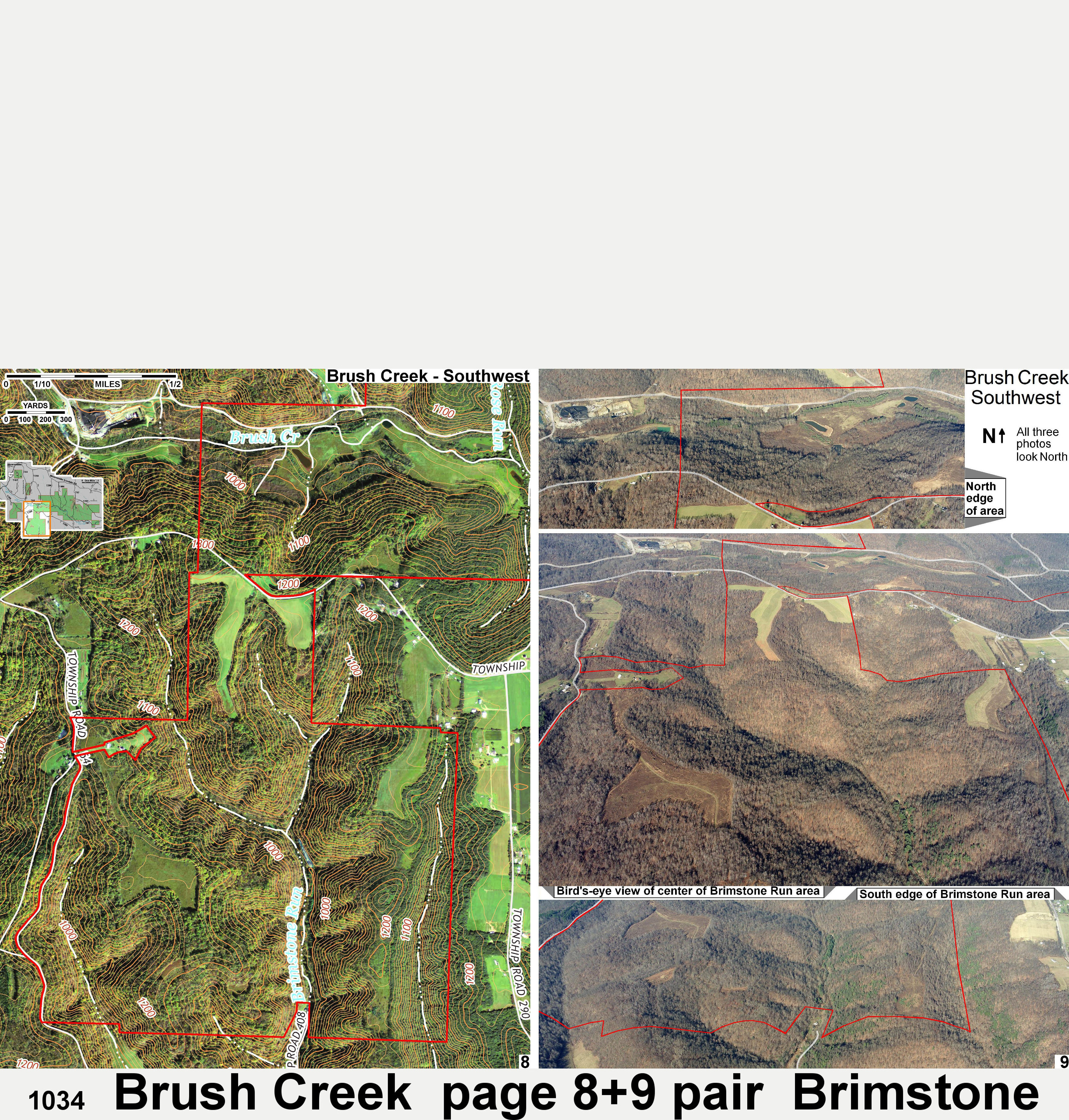
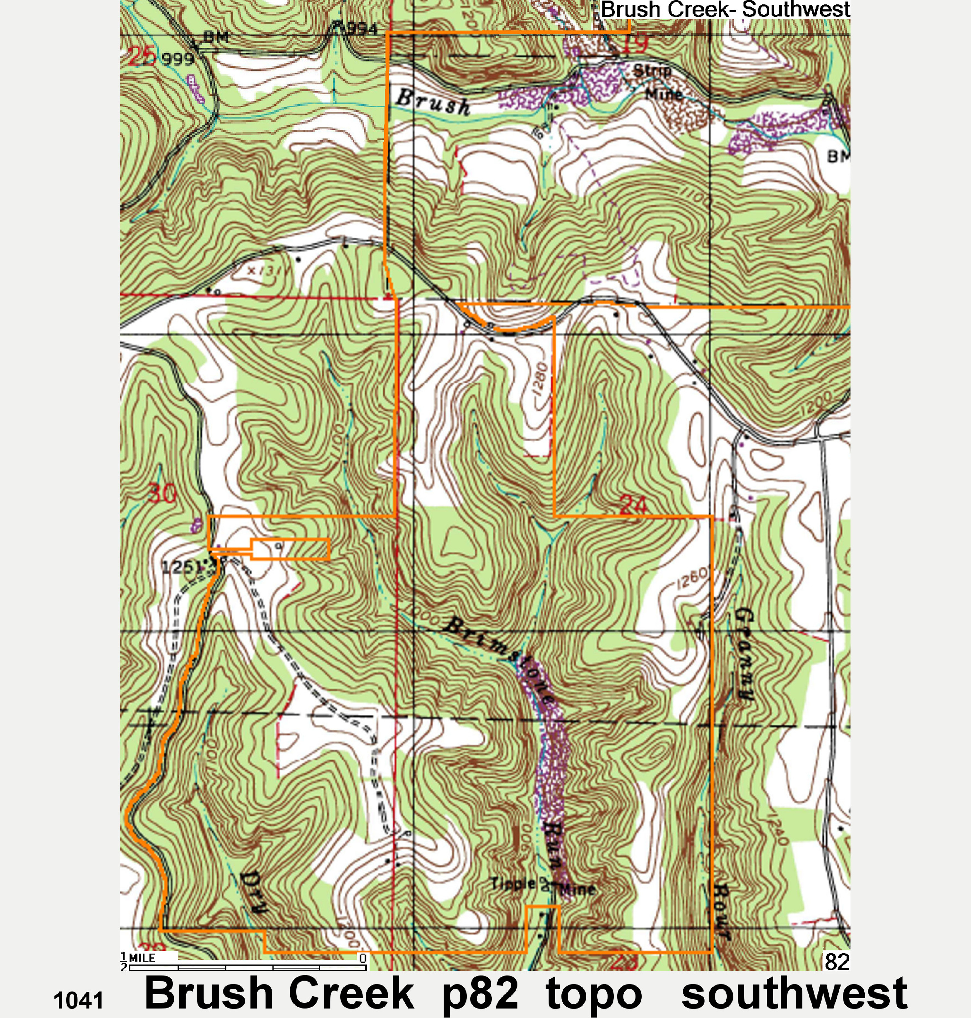
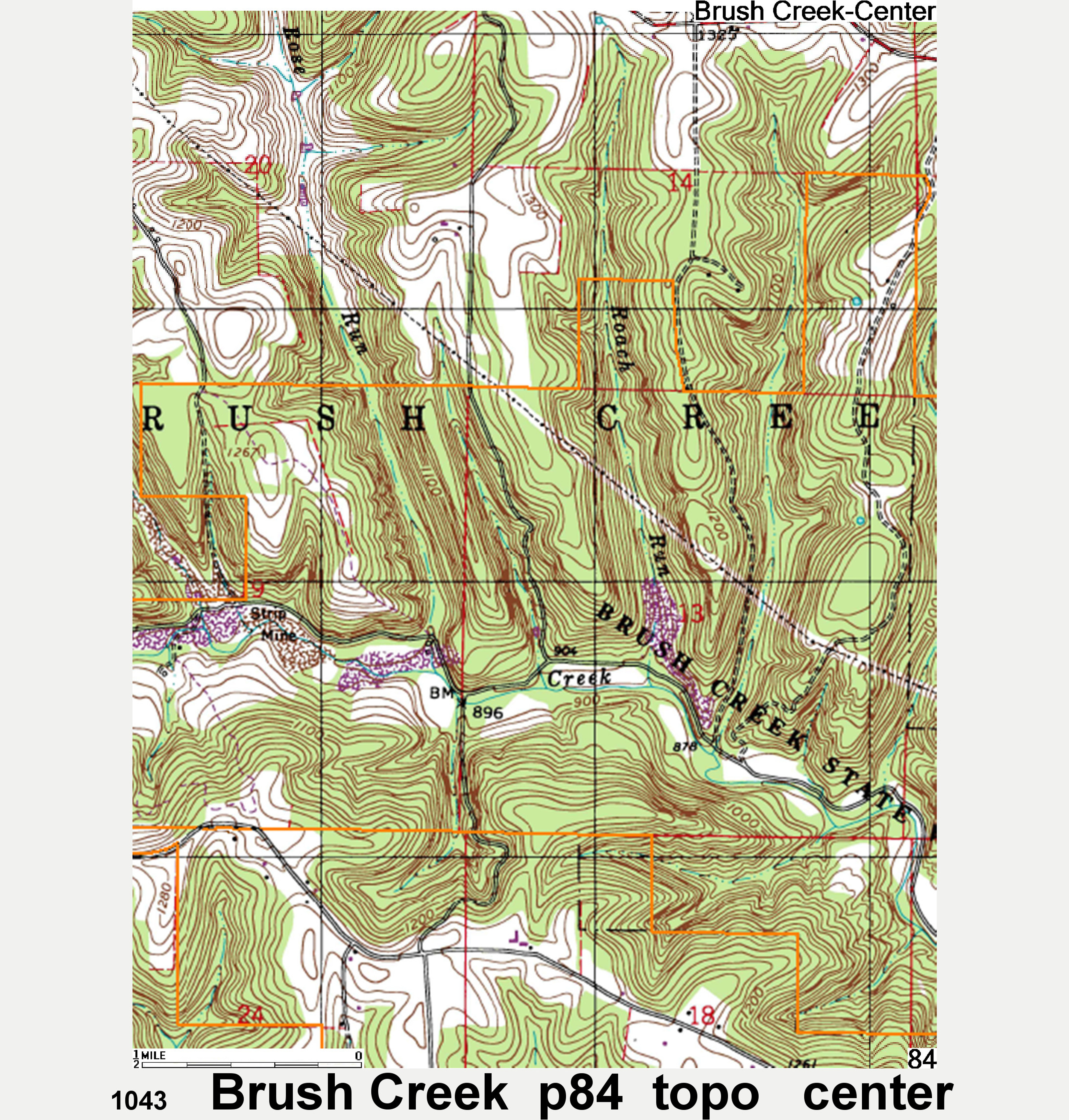
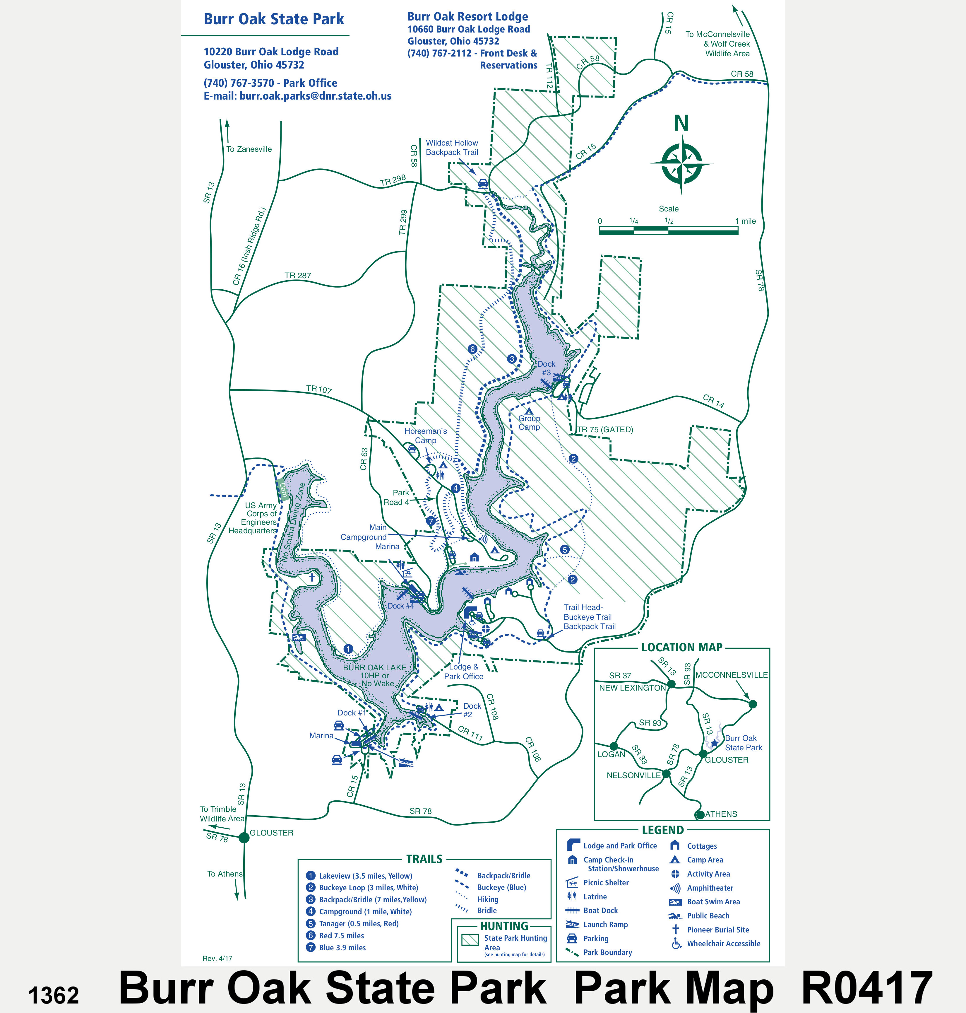
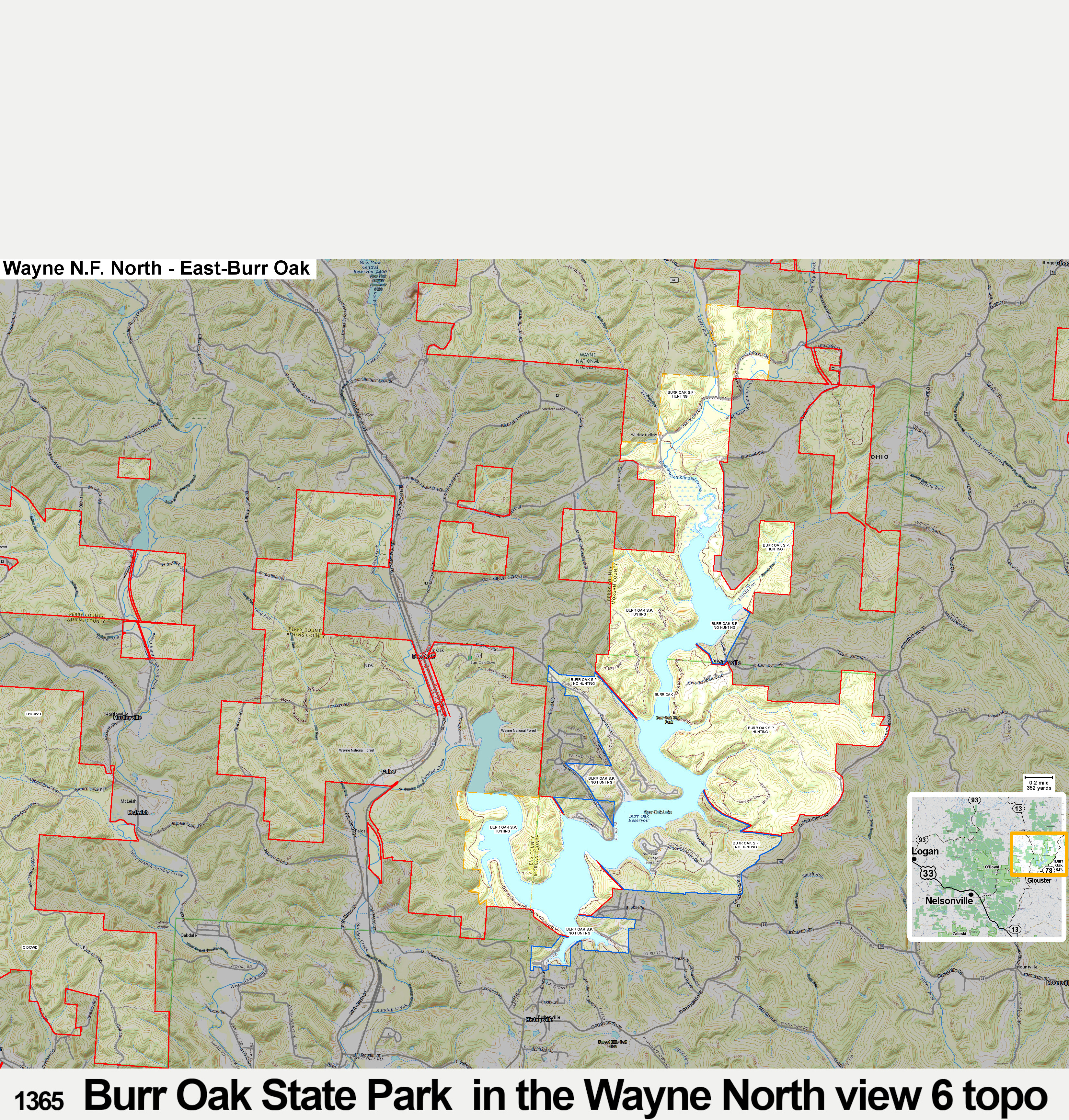
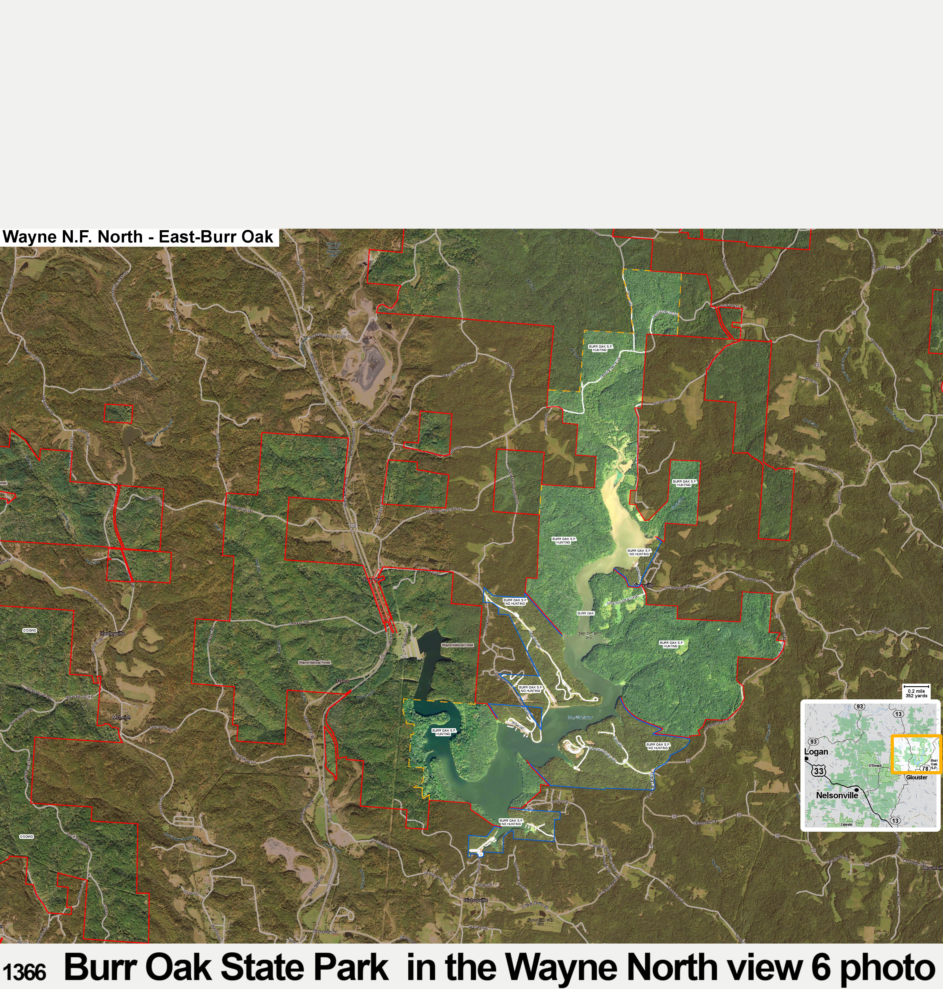
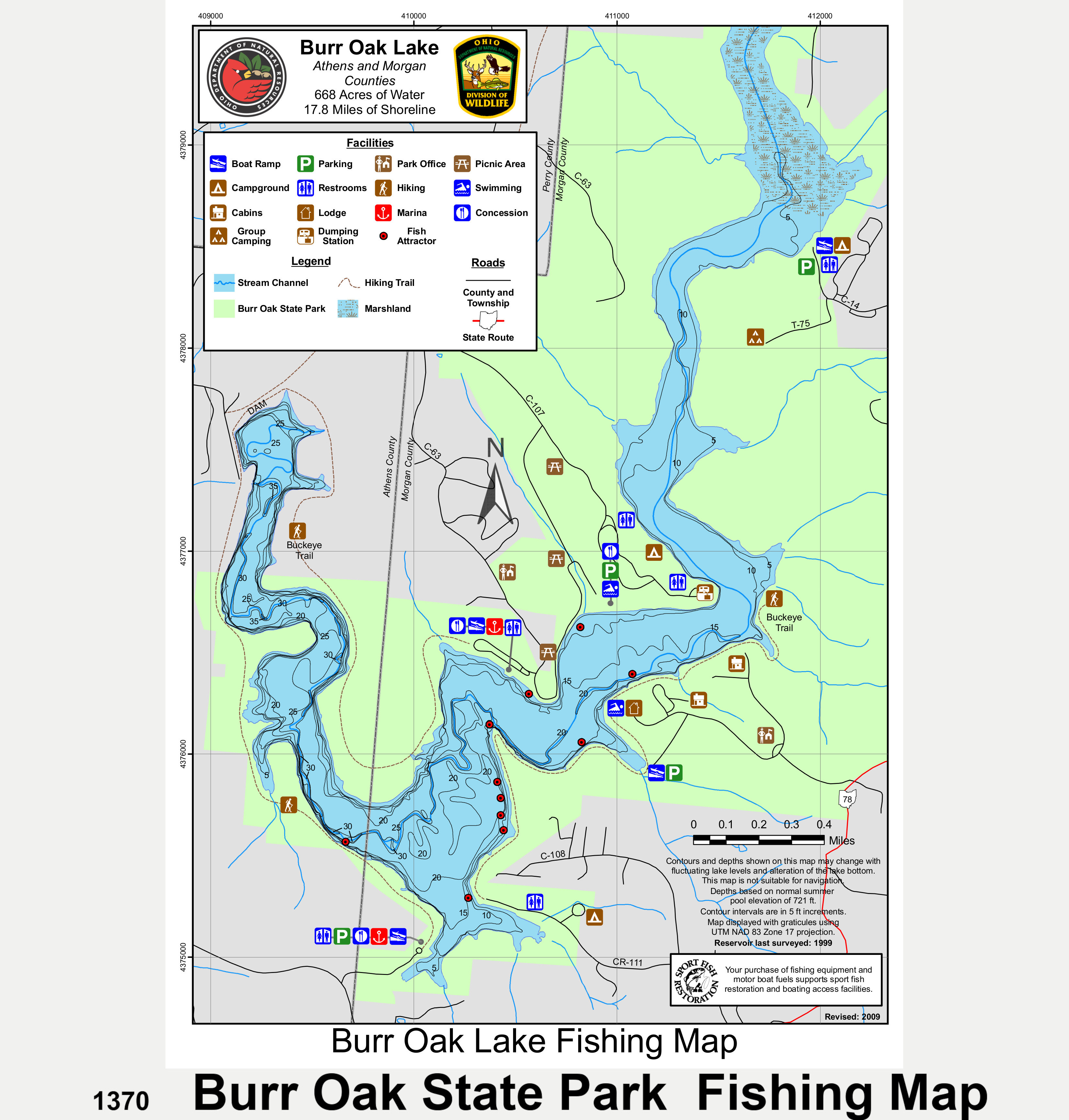
Keywords and search terms that a person might use to find maps and information on Ohio public hunting lands on the internet include: Hunting ohio public land, Best Ohio public hunting land, Deer hunting ohio public land, Best ohio public hunting areas, Ohio public hunting areas, Ohio hunting maps, Ohio public land maps, Ohio public deer hunting, Best Ohio public deer hunting, Ohio public hunting, Ohio public hunting maps, Best hunting on Ohio public land, Best Ohio public hunting areas, Acadia Cliffs, AEP Lands, AEP Appalachian Hills. AEP Avondale, AEP Conesville, AEP Gavin, AEP Poston Plant Lands, AEP ReCreation Land, AEP Southern Ohio, Akron Water, Ales Run, Ale’s Run, Andreoff North, Andreoff South, Andreoff, Appalachian Hills, Atwood Lake, Auburn Marsh, Avondale, B & N Coal Lands, Beach City, Beaver Creek, Beaver Creek S.F., Berlin Lake, Big Island, Blue Rock S.F., Bolivar Dam, Bott, Braceville, Broken ARO, Broken Arrow, Brook, Brush Creek, Brush Creek S.F., Burr Oak S.P., Caesar Creek Lake, Camp Belden, Cascade, Charles Mill Lake, Charles O. Trump, Clendening Lake, Coalton, Conant, Conesville, Conneaut, Consol Energy Powhatan Point area, Cooper Hollow, Crown City, Cuyahoga Valley N.P., Dan & Margaret James, Darke, Dean S.F., Deer Creek, Delaware, Dillon, Dorset, East Fork, Egypt Valley, Elm Road, Fallsville, Fallsville South, Fernwood S.F., Firestone-Yeagley, Fish Creek, Flint Run, Forked Run S.P., Fox Lake, Funk Bottoms, Gavin Power, Gifford S.F., Grand River, Hambden Orchard, Hancock County WPA 32-3, Harrison S.F., Hellbender Bluff, Highlandtown, Hocking S.F., Indian Creek, James, Jesse Owens State Park + wildlife area, Jockey Hollow, Keen, Killbuck Marsh, Killdeer Plains, Kinnikinnick, Knobby’s Prairie, Kokosing Lake, LaDue, Lake Erie Marsh zone and shore, Lake La Su An, Lake Logan S.P., Lake Park, Leesville, Lake, Liberty, Little Portage, Lower Killbuck Creek, Mackey Ford, Magee Marsh, Mallard Club Marsh, Marsh Wetlands, Maumee S.F., Mead Paper Lands, Mercer, Mesopotamia, Metzger Marsh, Milan, Missionary Island, Mogadore Reservoir, Mohawk Dam, Mohican River, Mohican S.F., Mohler, Monroe Lake, Mosquito Creek, MWCD Lakes, New Lyme, O’Dowd, ODOT Agreement Land, Ohio public land, Ohio road maps, Oldaker, Orwell, Oxbow Lake, Paint Creek Lake, Parkersburg, Pater, Perry S.F., Pickerel Creek, Piedmont Lake, Pike S.F., Pipe Creek, Pleasant Hill Lake, Pleasant Valley, Portage Lakes State Park, Portage Path, Poston Plant Lands, Powelson, Powhatan Point, Raccoon, ReCreation Land, Resthaven, Richland Furnace S.F., Ross Lake, Rush Run, Salt Fork, Samuels, Sawmill Wetland, Scenic Vista, Scioto Land Co., Scioto Trail S.F., Seneca County WPA 74-4, Seneca Lake, Shade River S.F., Shawnee S.F., Shenango, Shreve Lake, Silver Creek, Simco, Spencer Lake, Spring Valley, Stonelick S.P., Strouds Run S.P., Sugar Creek, Sunday Creek, Sunfish Creek S.F., Superior, Symmes, Tappan Lake, Tar Hollow S.F., Tiffin River, Toussaint, Tranquility, Trimble Township Community Forest, Tri-Valley, Trump, Turkey Ridge, Tycoon Lake, Valley Run, Van Tassel Island, Vinton Furnace S.F., Wallace H. O’Dowd, Warren, Waterloo, Wayne N.F. Marietta, Wayne N.F. Athens, Wayne N.F. Ironton, Wellington, Wellston, West Branch S.P., West Branch, West Farmington, Wildcat Hollow, Willard Marsh, Willow Point, Wills Creek Lake, Wingfoot Lake, Wolf Creek, Woodbury, Woodland Trails, Wyandot, Yellow Creek S.F., Zaleski S.F., Zepernick, Acadia Cliffs map, AEP Lands map, AEP maps, AEP Appalachian Hills map. AEP Avondale map, AEP Conesville map, AEP Gavin map, AEP Poston Plant Lands map, AEP ReCreation Land map, AEP Southern Ohio map, Akron Water map, Ales Run map, Ale’s Run map, Andreoff North map, Andreoff South map, Andreoff map, Appalachian Hills map, Atwood Lake map, Auburn Marsh map, Avondale map, B & N Coal Lands map, Beach City map, Beaver Creek map, Beaver Creek S.F. map, Berlin Lake map, Big Island map, Blue Rock S.F. map, Bolivar Dam map, Bott map, Braceville map, Broken ARO map, Broken Arrow map, Brook map, Brush Creek map, Brush Creek S.F. map, Burr Oak S.P. map, Caesar Creek Lake map, Camp Belden map, Cascade map, Charles Mill Lake map, Charles O. Trump map, Clendening Lake map, Coalton map, Conant map, Conesville map, Conneaut map, Consol Energy Powhatan Point area map, Cooper Hollow map, Crown City map, Cuyahoga Valley N.P. map, Dan & Margaret James map, Darke map, Dean S.F. map, Deer Creek map, Delaware map, Dillon map, Dorset map, East Fork map, Egypt Valley map, Elm Road map, Fallsville map, Fallsville South map, Fernwood S.F. map, Firestone-Yeagley map, Fish Creek map, Flint Run map, Forked Run S.P. map, Fox Lake map, Funk Bottoms map, Gavin Power map, Gifford S.F. map, Grand River map, Hambden Orchard map, Hambden map, Hancock County WPA 32-3 map, Harrison S.F. map, Hellbender Bluff map, Highlandtown map, Hocking S.F. map, Indian Creek map, James map, Jesse Owens State Park + wildlife area map, Jockey Hollow map, Keen map, Killbuck Marsh map, Killdeer Plains map, Kinnikinnick map, Knobby’s Prairie map, Kokosing Lake map, LaDue map, Lake Erie Marsh zone and shore map, Lake La Su An map, Lake Logan S.P. map, Lake Park map, Leesville Lake map, Liberty map, Little Portage map, Lower Killbuck Creek map, Mackey Ford map, Magee Marsh map, Mallard Club Marsh map, Marsh Wetlands map, Maumee S.F. map, Mead Paper Lands map, Mercer map, Mesopotamia map, Metzger Marsh map, Milan map, Missionary Island map, Mogadore Reservoir map, Mohawk Dam map, Mohican River map, Mohican S.F. map, Mohler map, Monroe Lake map, Mosquito Creek map, MWCD Lakes map, New Lyme map, O’Dowd map, ODOT Agreement Land map, Ohio public land map, Ohio road maps, Oldaker map, Orwell map, Oxbow Lake map, Paint Creek Lake map, Parkersburg map, Pater map, Perry S.F. map, Pickerel Creek map, Piedmont Lake map, Pike S.F. map, Pipe Creek map, Pleasant Hill Lake map, Pleasant Valley map, Portage Lakes State Park map, Portage Path map, Poston Plant Lands map, Powelson map, Powhatan Point map, Raccoon map, ReCreation Land map, Resthaven map, Richland Furnace S.F. map, Ross Lake map, Rush Run map, Salt Fork map, Samuels map, Sawmill Wetland map, Scenic Vista map, Scioto Land Co. map, Scioto Trail S.F. map, Seneca County WPA 74-4 map, Seneca Lake map, Shade River S.F. map, Shawnee S.F. map, Shenango map, Shreve Lake map, Silver Creek map, Simco map, Spencer Lake map, Spring Valley map, Stonelick S.P. map, Strouds Run S.P. map, Sugar Creek map, Sunday Creek map, Sunfish Creek S.F. map, Superior map, Symmes map, Tappan Lake map, Tar Hollow S.F. map, Tiffin River map, Toussaint map, Tranquility map, Trimble Township Community Forest map, Tri-Valley map, Trump map, Turkey Ridge map, Tycoon Lake map, Valley Run map, Van Tassel Island map, Vinton Furnace S.F. map, Wallace H. O’Dowd map, Warren map, Waterloo map, Wayne N.F. Marietta map, Wayne N.F. Athens map, Wayne N.F. Ironton map, Wellington map, Wellston map, West Branch S.P. map, West Branch map, West Farmington map, Wildcat Hollow map, Willard Marsh map, Willow Point map, Wills Creek Lake map, Wills Creek map, Wingfoot Lake map, Wolf Creek map, Woodbury map, Woodland Trails map, Wyandot map, Yellow Creek S.F. map, Zaleski S.F. map, Zepernick map, Acadia Cliffs hunting map, AEP Lands hunting map, AEP hunting maps, AEP Appalachian Hills hunting map, AEP Avondale hunting map, AEP Conesville hunting map, AEP Gavin hunting map, AEP Poston Plant Lands hunting map, AEP ReCreation Land hunting map, AEP Southern Ohio hunting map, Akron Water hunting map, Ales Run hunting map, Ale’s Run hunting map, Andreoff North hunting map, Andreoff South hunting map, Andreoff hunting map, Appalachian Hills hunting map, Atwood Lake hunting map, Auburn Marsh hunting map, Avondale hunting map, B & N Coal Lands hunting map, Beach City hunting map, Beaver Creek hunting map, Beaver Creek S.F. hunting map, Berlin Lake hunting map, Big Island hunting map, Blue Rock S.F. hunting map, Bolivar Dam hunting map, Bott hunting map, Braceville hunting map, Broken ARO hunting map, Broken Arrow hunting map, Brook hunting map, Brush Creek hunting map, Brush Creek S.F. hunting map, Burr Oak S.P. hunting map, Caesar Creek Lake hunting map, Camp Belden hunting map, Cascade hunting map, Charles Mill Lake hunting map, Charles O. Trump hunting map, Clendening Lake hunting map, Coalton hunting map, Conant hunting map, Conesville hunting map, Conneaut hunting map, Consol Energy Powhatan Point area hunting map, Cooper Hollow hunting map, Crown City hunting map, Cuyahoga Valley N.P. map, Dan & Margaret James hunting map, Darke hunting map, Dean S.F. hunting map, Deer Creek hunting map, Delaware hunting map, Dillon hunting map, Dorset hunting map, East Fork hunting map, Egypt Valley hunting map, Elm Road hunting map, Fallsville hunting map, Fallsville South hunting map, Fernwood S.F. hunting map, Firestone-Yeagley hunting map, Fish Creek hunting map, Flint Run hunting map, Forked Run S.P. hunting map, Fox Lake hunting map, Funk Bottoms hunting map, Gavin Power hunting map, Gifford S.F. hunting map, Grand River hunting map, Hambden Orchard hunting map, Hambden hunting map, Hancock County WPA 32-3 hunting map, Harrison S.F. hunting map, Hellbender Bluff hunting map, Highlandtown hunting map, Hocking S.F. hunting map, Indian Creek hunting map, James hunting map, Jesse Owens State Park + wildlife area hunting map, Jockey Hollow hunting map, Keen hunting map, Killbuck Marsh hunting map, Killdeer Plains hunting map, Kinnikinnick hunting map, Knobby’s Prairie hunting map, Kokosing Lake hunting map, LaDue hunting map, Lake Erie Marsh zone and shore hunting map, Lake La Su An hunting map, Lake Logan S.P. hunting map, Lake Park hunting map, Leesville Lake hunting map, Liberty hunting map, Little Portage hunting map, Lower Killbuck Creek hunting map, Mackey Ford hunting map, Magee Marsh hunting map, Mallard Club Marsh hunting map, Marsh Wetlands hunting map, Maumee S.F. hunting map, Mead Paper Lands hunting map, Mercer hunting map, Mesopotamia hunting map, Metzger Marsh hunting map, Milan hunting map, Missionary Island hunting map, Mogadore Reservoir hunting map, Mohawk Dam hunting map, Mohican River hunting map, Mohican S.F. hunting map, Mohler hunting map, Monroe Lake hunting map, Mosquito Creek hunting map, MWCD Lakes hunting map, New Lyme hunting map, O’Dowd hunting map, ODOT Agreement Land hunting map, Ohio public land hunting map, Ohio road maps, Oldaker hunting map, Orwell hunting map, Oxbow Lake hunting map, Paint Creek Lake hunting map, Parkersburg hunting map, Pater hunting map, Perry S.F. hunting map, Pickerel Creek hunting map, Piedmont Lake hunting map, Pike S.F. hunting map, Pipe Creek hunting map, Pleasant Hill Lake hunting map, Pleasant Valley hunting map, Portage Lakes State Park hunting map, Portage Path hunting map, Poston Plant Lands hunting map, Powelson hunting map, Powhatan Point hunting map, Raccoon hunting map, ReCreation Land hunting map, Resthaven hunting map, Richland Furnace S.F. hunting map, Ross Lake hunting map, Rush Run hunting map, Salt Fork hunting map, Samuels hunting map, Sawmill Wetland map, Scenic Vista hunting map, Scioto Land Co. hunting map, Scioto Trail S.F. hunting map, Seneca County WPA 74-4 hunting map, Seneca Lake hunting map, Shade River S.F. hunting map, Shawnee S.F. hunting map, Shenango hunting map, Shreve Lake hunting map, Silver Creek hunting map, Simco hunting map, Spencer Lake hunting map, Spring Valley hunting map, Stonelick S.P. hunting map, Strouds Run S.P. hunting map, Sugar Creek hunting map, Sunday Creek hunting map, Sunfish Creek S.F. hunting map, Superior hunting map, Symmes hunting map, Tappan Lake hunting map, Tar Hollow S.F. hunting map, Tiffin River hunting map, Toussaint hunting map, Tranquility hunting map, Trimble Township Community Forest hunting map, Tri-Valley hunting map, Trump hunting map, Turkey Ridge hunting map, Tycoon Lake hunting map, Valley Run hunting map, Van Tassel Island hunting map, Vinton Furnace S.F. hunting map, Wallace H. O’Dowd hunting map, Warren hunting map, Waterloo hunting map, Wayne N.F. Marietta hunting map, Wayne N.F. Athens hunting map, Wayne N.F. Ironton hunting map, Wellington hunting map, Wellston hunting map, West Branch S.P. hunting map, West Branch hunting map, West Farmington hunting map, Wildcat Hollow hunting map, Willard Marsh hunting map, Willow Point hunting map, Wills Creek Lake hunting map, Wills Creek hunting map, Wingfoot Lake hunting map, Wolf Creek hunting map, Woodbury hunting map, Woodland Trails hunting map, Wyandot hunting map, Yellow Creek S.F. hunting map, Zaleski S.F. hunting map, Zepernick hunting map.